
Elevation 1,297 m Listing Four-thousand footers | Prominence 78 m | |
 | ||
Easiest route Willey Range Trail via Mt. Field Parent ranges White Mountains, Appalachian Mountains Similar Mount Field, Mount Tom, Mount Hale, Mount Jackson, Mount Pierce | ||
Mount willey nh
Mount Willey is a mountain located in Grafton County, New Hampshire. The mountain is named after Samuel Willey, Jr. (1766–1826) and his family, who in 1825 moved into a house in Crawford Notch. Tragically the family was killed a year later in August 1826 during a landslide.
Contents
- Mount willey nh
- Map of Mt Willey Bethlehem NH 03583 USA
- Mount willey crawford notch state park nh
- References
Map of Mt Willey, Bethlehem, NH 03583, USA
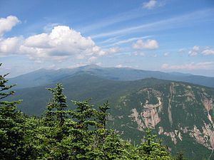
Mount Willey is part of the Willey Range of the White Mountains, of which it is the southernmost and second highest. It, along with Mount Field, forms the western wall of Crawford Notch. The summit is just outside the Crawford Notch State Park; it is at the northeast corner of the Pemigewasset Wilderness.
The north and east faces of Mount Willey drain directly into the Saco River, thence into the Gulf of Maine at Saco, Maine. The south and west sides drain into the North Fork of the Pemigewasset River, thence into the East Branch, the Pemigewasset River, Merrimack River, and into the Gulf of Maine at Newburyport, Massachusetts.