
Prominence 3,562 ft (1,086 m) Topo map USGS Mount Turnbull | Elevation 2,524 m | |
 | ||
Similar Roof Butte, Pinal Peak, Chiricahua Peak, Kendrick Peak, Mount Baldy | ||
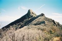
Mount Turnbull is the highest point in the Santa Teresa Mountains in western Graham County, Arizona. The summit has an elevation of 8,284 feet (2,525 m) and a prominence of 3,562 feet (1,086 m). It is the highest point in the Santa Teresa Mountains and the San Carlos Apache Indian Reservation. A recreational permit is required for access to reservation land.
Map of Mt Turnbull, Arizona 85530, USA
References
Mount Turnbull (Arizona) Wikipedia(Text) CC BY-SA