
Topo map USGS Mount Tripyramid Prominence 402 m | Elevation 1,268 m Listing Four-thousand footers | |
 | ||
Similar Mount Passaconaway, Mount Whiteface, East Peak Mount Osceola, Mount Tecumseh, Mount Carrigain | ||
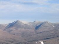
Mount Tripyramid is a mountain located in Grafton County, New Hampshire. The mountain, so-called because of the three distinct peaks along its mile-long summit ridge, is part of the Sandwich Range of the White Mountains. Scaur Peak and The Fool Killer are subsidiary peaks to the northwest and northeast. To the southeast, Tripyramid is flanked by The Sleepers.
Map of Mt Tripyramid, Waterville Valley, NH 03259, USA
Mt. Tripyramid is drained on the west side by Slide Brook and Avalanche Brook, thence into the Mad River, Pemigewasset River, Merrimack River, and into the Gulf of Maine at Newburyport, Massachusetts. Tripyramid is drained on the east side by Sabbaday Brook, thence into the Swift River, Saco River, and into the Gulf of Maine at Saco, Maine. Tripyramid is drained on the north side by Pine Bend Brook, another tributary of the Swift River.
Both North and Middle Tripyramid are included in the Appalachian Mountain Club's list of New England "four-thousand footers". Although over 4,000 feet in height, South Tripyramid is not, because it stands less than 200 ft above the col on the ridge from Middle Tripyramid.