
Topo map USGS Waterville Valley Prominence 525 m Listing Four-thousand footers | Elevation 1,220 m Mountain range Sandwich Range | |
 | ||
Similar Mount Tripyramid, Mount Osceola, East Peak Mount Osceola, Mount Whiteface, Mount Tom | ||
Mount tecumseh virtual hike nh 4 000 footers
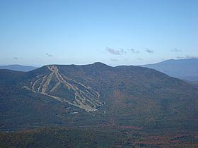
Mount Tecumseh is a mountain located in Grafton County, New Hampshire. The mountain is named after the Shawnee leader Tecumseh (c.1768–1813), and is a part of the White Mountains. The east side of Tecumseh drains into the Mad River; the west side drains into several brooks. All are tributaries of the Pemigewasset River, which drains into the Merrimack River and thence into the Gulf of Maine in Massachusetts.
Contents
- Mount tecumseh virtual hike nh 4 000 footers
- Map of Mt Tecumseh Waterville Valley NH 03285 USA
- Mount tecumseh winter hike
- References
Map of Mt Tecumseh, Waterville Valley, NH 03285, USA
Mount Tecumseh is the site of the Waterville Valley Resort, one of the largest ski areas in New Hampshire.
At 4,003 feet in height, Mt. Tecumseh is the lowest on the Appalachian Mountain Club list of "four-thousand footers".
Mount tecumseh winter hike
References
Mount Tecumseh Wikipedia(Text) CC BY-SA