
Elevation 3,428 m Last eruption September 2014 | Prominence 3,284 m | |
 | ||
Isolation 420 kilometres (260 mi) Similar Mount Sumbing, Mount Sundoro, Mount Merbabu, Semeru, Mount Cereme | ||
Pendakian gunung slamet via bambangan banda neira hujan di mimpi
Mount Slamet or Gunung Slamet is an active stratovolcano in the Purbalingga Regency of Central Java, Indonesia. It has a cluster of around three dozen cinder cones on the lower southeast-northeast flanks and a single cinder cone on the western flank. The volcano is composed of two overlapping edifices. Four craters are found at the summit. Historical eruptions have been recorded since the eighteenth century.
Contents
- Pendakian gunung slamet via bambangan banda neira hujan di mimpi
- Map of Mount Slamet Gunungsari Pulosari Pemalang Regency Central Java Indonesia
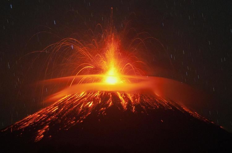
- Mount slamet gunung slamet made strombolian eruption on aug 26 2014
- September 2014Edit
- References
Map of Mount Slamet, Gunungsari, Pulosari, Pemalang Regency, Central Java, Indonesia
Gunung Slamat was closed to climbers for much of 2010 and 2011 but was re-opened in late 2011. A large number of climbers were expected to visit to peak on New Year's Eve 2012 to celebrate the new year.
The volcano erupted in 2009 and again in September 2014.
Mount slamet gunung slamet made strombolian eruption on aug 26 2014
September 2014Edit
Mount Slamet erupted again Wednesday (18th) after four days of remaining quiet. The volcano, dormant since 2009, began erupting again in late August prompting authorities to raise alert levels in the area. While the eruption was not considered to be a large one, a nearby forest was razed and authorities have blocked off a 2.5 mile radius in case of increased activity. Residents have otherwise remained calm in the region.