
Prominence 2,792 m Last eruption 1951 | Elevation 3,078 m | |
 | ||
Similar Gunung Cikuray, Mount Papandayan, Mount Slamet, Mount Gede, Mount Pangrango | ||
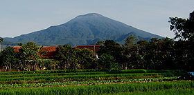
Mount cereme kuningan west java indonesia
Mount Ciremai/Cereme (or Ciremay) is a dominating symmetrical stratovolcano in West Java, Indonesia. It is located to the southwest of the major town of Cirebon. Mt Ciremai is strikingly visible towards the south from the main west-east corridor (Jakarta-Surabaya) rail link along the north coast of Java. It is the highest point of West Java.
Contents
- Mount cereme kuningan west java indonesia
- Map of Mount Cereme Bantaragung Sindangwangi Majalengka Regency West Java Indonesia
- Argalinga on mount cereme majalengha
- Climbing Mt Cereme
- Around Mt Cereme
- References
Map of Mount Cereme, Bantaragung, Sindangwangi, Majalengka Regency, West Java, Indonesia
At the summit of Mt Ciremai there is a 4.5 × 5 km wide caldera. Eruptions are relatively infrequent in historical time but explosive activity and lahars from the summit have been recorded. Mount Ceremai is especially significant because it is the highest mountain in the province of West Java. The name Cereme or Ciremai is derived from Sundanese word for Otaheite gooseberry.
There are numerous recreational and tourist sites on the slopes of Mt Ciremai. Various sites, including parks and cafes, attract crowds of visitors from Cirebon. The museum at Linggajati on the slopes of Mt Ceremai which records the important historical event of the Linggadjati Agreement during the struggle for Indonesian Independence in 1946 attracts many visitors during weekends. The Mt Ciremai National Park extends for a considerable distance around the slopes of the mountain.
On Mt Ciremai, as on many other mountains up and down Java, there has been serious deforestation in recent decades. It was reported in late 2012 that forest destruction on Mt Ciremai had reached 4,000 ha out of a total of 15,000 ha. Causes are said to include illegal logging, sand quarrying (often for construction purposes in nearby areas), and forest fires. Some of the consequences of deforestation of this kind, evident in the Cirebon area close to the sea near Mt Ciremai, include extensive siltation of the rivers which flow northwards into the Java sea and more frequent flooding in lowland areas.
Numbers of small streams has their source in the slopes of Mt Cereme. Most of them went northwest towards Majalengka to join the large Cimanuk River in the northwest that drain to Java sea near Indramayu. On the southeastern side, the Waduk Darma serves as the reservoir near the stream that drain eastward as Cisanggarung River that later curved and heading north to marked the boundary between West Java and Central Java.
Argalinga on mount cereme majalengha
Climbing Mt Cereme
Groups of hikers, including parties of students, regularly climb the peak. The climb, which often takes 12 hours or more for the round trip, involves camping on the mountain for a night for some groups. As is frequently the case in other parts of Indonesia, groups are expected to register with local officials before beginning the climb. Care is needed because inexperienced hikers sometimes run into considerable difficulties. Groups often begin the climb from Linggajati in the east, Palutungan from the south near the town of Cigugur, or Majalengka to the west.
A useful guide to climbing Mt Ciremai is on the Gunung Bagging website for the mountain.
Around Mt Cereme
The eastern slope of Mt Cereme has several interesting places, popular among tourists and visitors. Near the town of Cilimus (between Cirebon and Kuningan city), there is a natural volcanic hot springs of Sangkanhurip. It is a popular tourism spot for spa and relaxation among people of Cirebon and Kuningan. The clear spring water and ponds of Cigugur and Cibulan is a natural water swimmingpool which also the sanctuary of rare Kancra bodas fish, which are considered sacred fish among locals. Forest sanctuary can be found on the slopes around the summit, however the popular forest sanctuary is in Linggajati, on eastern slopes. On the Southeastern slopes near the city of Kuningan, there is Cipari megalithic site which is important archaeological site of Indonesian prehistoric period.