
Location Kanagawa, Japan First ascent unknown | Elevation 1,340 m Easiest route Hiking | |
 | ||
Similar Karasuoyama, Sannoto, Ninoto, Mount Tō, Mount Tanzawa | ||
Columbia gorge the fruit loop hood river multnomah falls
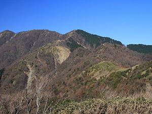
Mount Shindainichi (新大日) is a peak of the Tanzawa Mountains with an elevation of 1,340 metres (4,396 ft), and is located due east of Mount Tō. It is located within the boundary of the Tanzawa-Ōyama Quasi-National Park.
Contents
- Columbia gorge the fruit loop hood river multnomah falls
- Map of Mount Shindainichi Susugaya Kiyokawa Aiko District Kanagawa Prefecture 243 0112 Japan
- References
Map of Mount Shindainichi, Susugaya, Kiyokawa, Aiko District, Kanagawa Prefecture 243-0112, Japan
The mountain is easily accessible by a hiking trail from Yabitsu Pass, which intersects with the Nagaone Trail from the village of Kiyokawa, and with the trail leading directly to Mount Tō which is approximately a 40-minute hike.
References
Mount Shindainichi Wikipedia(Text) CC BY-SA