Established 1996 Time zone ACST (UTC+9:30) Mean max temp Mean min temp | Postcode(s) 5291 Postal code 5291 | |
 | ||
Location 385 km (239 mi) south-east of Adelaide city centre14 km (9 mi) south of Mount Gambier | ||
Hiking to the top of mount schank south australia
Mount Schank is a locality in the Australian state of South Australia located about 385 kilometres (239 mi) south-east of the Adelaide city centre and 14 kilometres (8.7 mi) south of the centre of Mount Gambier in the south-east of the state.
Mount Schank originally began as a private sub-division of land within the cadastral unit of the Hundred of MacDonnell. Boundaries were created in October 1996 for the “long established name.”
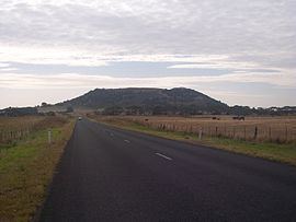
Mount Schank consists of land adjoining both sides of the Riddoch Highway between Mount Gambier to the north and Port MacDonnell to the south. The locality includes a number of geological features consisting of the extinct volcano, Mount Schank which is located on the eastern side of the Riddoch Highway and a number of water-filled sinkholes such as the Little Blue Lake located on land to the west of the Riddoch Highway. The majority land use within the locality is agriculture with an area located between the Riddoch highway and the western side of the extinct volcano is zoned for industrial purposes.
The following places within Mount Schank are listed on the South Australian Heritage Register:
Mount Schank is located within the federal division of Barker, the state electoral district of Mount Gambier and the local government area of the District Council of Grant.
