
Isolation 13.58 mi (21.9 km) Easiest route West ridge, class 2 Prominence 810 m | Parent range Sawatch Mountains Elevation 4,255 m | |
 | ||
Listing North America highest peaks 65thUS highest major peaks 49thColorado highest major peaks 27th Topo map USGS 7.5' topographic mapMount Ouray, Colorado Similar Grizzly Peak, Vermilion Peak, Casco Peak, French Mountain, Clinton Peak | ||
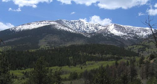
Mount Ouray is a high and prominent mountain summit in the far southern Sawatch Range of the Rocky Mountains of North America. The 13,961-foot (4255.4 m) thirteener is located in San Isabel National Forest, 7.5 miles (12.0 km) west (bearing 270°) of Poncha Pass, Colorado, United States, on the boundary between Chaffee and Saguache counties. The mountain was named in honor of Ute Chief Ouray.
Contents
Map of Mt Ouray, Colorado 81201, USA
MountainEdit
Mount Ouray makes up the southern tip of Sawatch Mountains, rising 7,000 feet above the Arkansas River Valley. Monarch Pass is four miles northwest of the peak.
The mountain is named after the Ute Chief Ouray. Nearby Mount Chipeta, just over a mile to the northwest of Mount Ouray, is named after Chief Ouray's wife.
RoutesEdit
The standard route is the west ridge. Starting at Marshall Pass, the route heads north along the Continental Divide until the west ridge of Mount Ouray is reached. From there, one can hike east along this ridge up to the summit.