
Elevation 1,330 m | Volcanic arc/belt Kurile arc | |
 | ||
Topo map Geospatial Information Authority 25000:1 遠音別岳25000:1 真鯉50000:1 斜里50000:1 標津 Last eruption ca. 0.4-0.2 million years ago Similar Mount Unabetsu, Mount Shiretoko, Mount Iō, Mount Chinishibetsu, Mount Rausu | ||
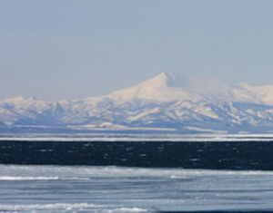
Mount Onnebetsu (遠音別岳, Onnebetsu-dake) is a quaternary stratovolcano. Its summit is 1,330.2 metres (4,364 ft). It is located on Hokkaido's Shiretoko Peninsula on the border of Shari in Shari District, Abashiri and Rausu in Menashi District, Nemuro.
Contents
- Map of Mount Onnebetsu Utorokogen Shari Shari District Hokkaido Prefecture 099 4352 Japan
- Geology
- References
Map of Mount Onnebetsu, Utorokogen, Shari, Shari District, Hokkaido Prefecture 099-4352, Japan
Geology
The mountain is made mainly of andesite.
References
Mount Onnebetsu Wikipedia(Text) CC BY-SA