
Elevation 3,636 m Prominence 1,673 m First ascender W. W. Phelps | First ascent 1869 Easiest route Hiking | |
 | ||
Listing US most prominent peaks 91stUtah county high points 10th Similar Mount Timpanogos, Loafer Mountain, Kings Peak, Deseret Peak, Mount Peale | ||
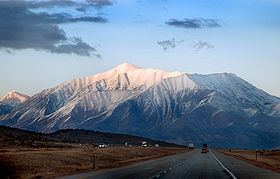
Mount Nebo is the southernmost and highest mountain in the Wasatch Range of Utah, in the United States. Named after the biblical Mount Nebo overlooking Israel, which is said to be the place of Moses' death, it is the centerpiece of the Mount Nebo Wilderness, inside the Uinta National Forest.
Map of Mt Nebo, Utah 84651, USA
Mount Nebo has two summits, with the North summit reaching 11,933 feet (3,637 m) NAVD 88. The southern summit reaches 11,882 feet (3,622 m) NAVD 88. Original surveys placed the southern peak as the highest. The mountain was resurveyed in the 1970s and the North peak was found to be the highest. The mountain is partially or completely covered in snow from mid-October until July. Nearby towns include Payson, Nephi and Provo.
A substantial trail leads to the south summit, accessible from starting points on the East or West of the mountain. Another trail accesses the North peak, starting Northeast of the mountain. A 'bench trail' runs along the east side of the mountain from North to South at roughly 9,000' feet elevation. All of these trails are popular, although strenuous, destinations for hikers; and many are dangerous places for horseback riders. One old-time local rider warns: "There's dead horses in every canyon on that mountain!"
The Mount Nebo Scenic Byway, a National Scenic Byway, departs I-15 at Payson and climbs to over 9,000 feet before rejoining the interstate at Nephi. The route features panoramic views of Mount Nebo and the Utah Valley and Utah Lake far below. There are numerous trailheads along the route for the hiking enthusiast including a short walk to the "Devil's Kitchen", an area which has been described as a "mini Bryce Canyon".