
Prominence 1,606 m | Elevation 3,582 m | |
 | ||
Listing US most prominent peaks 106th Similar Mount Nebo, Y Mountain, Lone Peak, Kings Peak, Pfeifferhorn | ||
Hiking mount timpanogos timpooneke trail
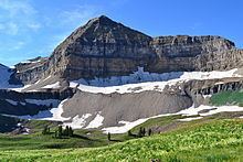
Mount Timpanogos, sometimes informally referred to as Timp, is the second highest mountain in Utah's Wasatch Range. Timpanogos rises to an elevation of 11,752 ft (3,582 m) above sea level in the Uinta-Wasatch-Cache National Forest. With 5,270 feet of topographic prominence, Timpanogos is the 47th-most prominent mountain in the contiguous United States.
Contents
- Hiking mount timpanogos timpooneke trail
- Map of Mt Timpanogos Utah 84604 USA
- Mount timpanogos wasatch mountains utah 4k
- Glacial activityEdit
- HikingEdit
- GeologyEdit
- HazardsEdit
- FolkloreEdit
- References
Map of Mt Timpanogos, Utah 84604, USA
The mountain towers about 7,000 feet over Utah Valley, including the cities of Lehi, Provo, Orem, Pleasant Grove, American Fork, Lindon and others. The exposed portion of the mountain is made up entirely of limestone and dolomite from the Pennsylvanian period, and is about 300 million years old. Heavy winter snowfall is characteristic of this portion of the Wasatch Range, and avalanche activity is common in winter and spring. The mountain is also home to Timpanogos Cave National Monument, a series of decorated caves in the north end of the mountain that have guided ranger tours open daily to the public during the warmer months.
The word Timpanogos comes from the Timpanogots tribe who lived in the surrounding valleys from AD 1400. The name translates as "rock" (tumpi-), and "water mouth" or "canyon" (panogos).
Mount timpanogos wasatch mountains utah 4k
Glacial activityEdit
Mount Timpanogos displays many examples of various glacial processes and the sculpting power of moving ice. Ice Age glaciers mantled the peak until relatively recently, and dramatically shaped the mountain into an Alpine tableau of knife-edge ridges and yawning, U-shaped amphitheaters. A remnant of these glaciers persists in the deeply recessed hanging valley below the main summit. Timpanogos Glacier is a rock-covered mass found on a long, north-facing slope, and usually has patches of snow the entire year. Although an above ground cirque glacier was present before the Dust Bowl Drought of the 1930s, no glacial ice is visible today. However, in 1994, a large crevasse opened up, revealing that there still is a glacier buried beneath the talus. Flowing water can occasionally be heard beneath the rocks. Emerald Lake, a small proglacial lake at the bottom of the cirque, often exhibits a blue color, indicating that the glacier is probably still moving, although perhaps too slowly to be noticeable. The locally unique ice is a relic of the region's formerly colder climate and has long been a major attraction to hikers and climbers on the mountain, who often slide down its permanent snowfield as a shorter descent route. Its precise classification remains the subject of spirited ongoing debate, whether "real" or not.
HikingEdit
Mount Timpanogos is one of Utah's most popular hiking/climbing destinations and is climbed year round. Winter climbing requires advanced mountaineering ability. In spring, undercutting of deeply drifted snow by streams creates a hazard that has proven fatal on several occasions. Climbers can fall through the undermined snow fifty feet or more into the icy stream underneath.
Although it is a 14-mile round-trip hike, with almost a mile of elevation gain, Timp's summit is one of the most-visited in the Rocky Mountains. There are two main trails to the top: the first starts at Aspen Grove with a trailhead elevation of 6,910 feet (2,106 meters), and the second starts at the Timpooneke campground in American Fork Canyon at 7,370 feet (2,185 meters). The two trails are nearly the same length. Hikers on the trails climb through montane forest, subalpine and alpine zones. The hike is marked by waterfalls, conifers, rocky slopes and ridges, mountain goats, and a small lake, Emerald Lake, at 10,380 feet (3,164 m). A short diversion will lead hikers past a World War II bomber crash site. Other climbing routes exist on the mountain, but they are more technically demanding and require special skills and mountaineering gear.
Prior to 1970, an annual Provo event called the "Timp Hike" sent thousands of people up the mountain's slopes. From 1911 to 1970 this one-day event (which took place generally on the third or fourth weekend in July) attracted thousands of people to the mountain. It also created the need for infrastructure, such as the stone shelter built in 1959 near Emerald Lake and a smaller metal shack on the summit (this was used as an observation deck complete with brass rods etched with notches aligned with various landmarks). The hike caused environmental damage to the mountain, and was finally canceled to help preserve the delicate mountain ecosystem. Despite the presence of the existing structures, the mountain was designated a wilderness area by the U.S. Congress in 1984.
GeologyEdit
The rock which forms the visible surface of Mount Timpanogos is primarily limestone composed of compacted sediment laid down onto an ancient seafloor over millions of years during the late Carboniferous Period (roughly 300 million years ago). Older rock exists beneath the limestone on the surface. The limestone was subsequently lifted high above sea level and the mountain itself became prominent as the Western valley sunk due to basin and range faulting. The most contemporary features of the mountain were formed through recent glacial and water erosion.
HazardsEdit
Since 1982 the Timpanogos Emergency Response Team ("TERT") has been established on the mountain on weekends to provide first aid, rescue and communication.[1].
The Timp Glacier is one of the major sources of injury or death to hikers on Timp, particularly when some attempt to "glissade" (or slide rapidly) down the snowfield's surface with the assistance of a shovel or other device to save time descending. There have been many cases of injuries from buried rocks under the snow as well. There have been numerous life flight rescues on the mountain, often caused by this activity. The frequency of these rescues, however, greatly diminished once TERT was established.
FolkloreEdit
In the early 1900s Eugene Lusk "Timp" Roberts, a professor at Brigham Young University, initiated an annual hike and pageant intended to "sell Timpanogos to the world." One way was to craft his take on native people's folklore. Some observers believe the ridgeline of Mount Timpanogos superficially resembles a sleeping woman. Roberts wrote his folk tale of the maiden Utahna and her sacrifice to her gods with this as the launch point, with one version the basis for a ballet.