
Age of rock Unknown Elevation 2,705 m | Prominence 2,055 m Listing Ultra-prominent peak | |
 | ||
Similar Mount Takahe, Toney Mountain, Mount Siple, Mount Andrus, Mount Berlin | ||
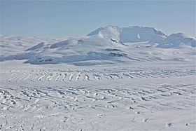
Mount Murphy is a massive, snow-covered and highly eroded shield volcano with steep, rocky slopes. It is directly south of Bear Peninsula, Marie Byrd Land, Antarctica. The mountain is bounded by the Smith, Pope and Haynes Glaciers.
Contents
Map of Mount Murphy, Antarctica
Delineated from aerial photographs taken by US Navy Operation Highjump in January 1947. Named by US-ACAN for Robert Cushman Murphy of the American Museum of Natural History, noted authority on Antarctic and sub-Antarctic bird life. While serving on the whaler, he charted the Bay of Isles region of South Georgia.
Features
Bucher Peak (75°20′S 110°52′W) at 2,445 metres (8,020 ft), is one of the highest peaks in the west-central summit area of the Mount Murphy massif. Buettner Peak is a sharp peak rising midway along the north wall of Roos Glacier in the northwest part of the Mount Murphy massif