
Topo map USGS Mount Morgan Elevation 4,193 m Mountain range Sierra Nevada Parent range Sierra Nevada | Easiest route Scramble, class 2 Prominence 801 m | |
 | ||
Listing North America highest peaks 80thUS highest major peaks 62ndCalifornia highest major peaks 10thSierra Peaks SectionWestern States Climbers Emblem peak Similar Mount Keith, Mount Kaweah, Mount Humphreys, Mount Barnard, Mount Darwin | ||
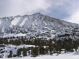
Mount Morgan is a mountain located in northwestern Inyo County, California, in the John Muir Wilderness of the Inyo National Forest.
Contents
Map of Mt Morgan, California 93514, USA
GeographyEdit
Morgan stands within the endorheic watershed of Owens Lake, now a mostly dry lake since its main source of water, the Owens River, was diverted to supply Los Angeles. The west and north sides of Mt. Morgan drain into Rock Creek, thence into the Owens River. The east and south sides of Morgan drain into Morgan Creek, thence into Pine Creek, and into lower Rock Creek.
ClimbingEdit
Morgan can be accessed by trail from Rock Creek Canyon, above Tom's Place on 395. Its trailhead is at the far end of the lake. The trail is well marked the first 4 miles (6.4 km) to Francis Lake, where it ends. From there it is a scramble up rocky slopes for 2 miles (3.2 km) to the summit.
HistoryEdit
In 1878 members of the Wheeler Survey, who made the first ascent in about 1870, named the mountain for one of its members, J.H. Morgan of Alabama.