
Parent range Sierra Nevada Elevation 4,100 m Mountain range Sierra Nevada | Prominence 137 m | |
 | ||
Listing Sierra Peaks SectionWestern States Climbers Emblem peak Easiest route Exposed scramble, class 3 Similar Mount Abbot, Mount Morgan, Birch Mountain, Mount McAdie, Mount Barnard | ||
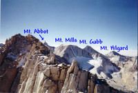
Mount Mills is a Thirteener and California 4000 meter peak, on the Sierra Crest, north of Mount Abbot and south of Mono Pass in the Sierra Nevada.
Contents
Map of Mt Mills, California 93634, USA
The mountain is located within the John Muir Wilderness area. The 13,457 feet (4,102 m) summit marks the boundary between northwestern Inyo County and eastern Fresno County.
The Mono Recesses are to the west of Mount Mills.
History
The mountain is named in honor of Darius Ogden Mills, a banker who founded the city of Millbrae, California and the Carson and Colorado Railroad. The name appeared on the first edition of the Mt Goddard topographic map in 1912.
References
Mount Mills (California) Wikipedia(Text) CC BY-SA