
Territorial authority Local time Monday 4:37 PM | Region Bay of Plenty Elevation 232 m Population 19,065 (2013) | |
 | ||
Ward Mount Manunganui/Papamoa Named for Mount Maunganui (Mauao) Weather 22°C, Wind W at 24 km/h, 60% Humidity Points of interest Mount Maunganui, The Mount, Mount Drury Reserve, Classic Flyers Museum | ||
Mount maunganui new zealand
Mount Maunganui /ˈmɒŋɡəˌnuːi/ is a major residential, commercial and industrial suburb of Tauranga, located on a peninsula to the north-east of Tauranga's city centre. It was an independent town from Tauranga until the completion of the Tauranga Harbour Bridge in 1988, which connects Mount Maunganui to Tauranga's central business district.
Contents
- Mount maunganui new zealand
- Map of Mount Maunganui Tauranga New Zealand
- Mount maunganui tauranga new zealand
- Geography
- Politics
- History
- Character
- Sport
- Artificial reef
- Climate
- References
Map of Mount Maunganui, Tauranga, New Zealand
Mount Maunganui is also the name of the large lava dome which was formed by the upwelling of rhyolite lava about two to three million years ago. It is officially known by its Māori name Mauao, but is colloquially known in New Zealand simply as The Mount.
Mount maunganui tauranga new zealand
Geography
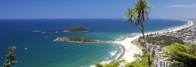
Mount Maunganui is located atop a sand bar that connects Mauao to the mainland, a geographical formation known as a tombolo. Because of this formation, the residents of Mount Maunganui have both a harbour beach (Pilot Bay) and an ocean beach with great surf, within a short distance. At the base of Mauao, the distance between the harbour and ocean side is a couple of blocks.
The ocean beach has Mauao or Mount Maunganui at its western end, and a man made land bridge connecting Moturiki Island at its eastern end.
Adjacent to Mount Maunganui on its south-eastern edge (from Sandhurst Drive onwards) is Papamoa Beach, another very large suburb of Tauranga. Papamoa Beach has a slightly larger population than Mount Maunganui, but doesn't have as many businesses as Mount Maunganui. Both suburbs are distinctly geographically separate from the rest of Tauranga by the Tauranga Harbour; two road bridges (SH2 and SH29) and a windy rural road (Welcome Bay Road) are the only feasible access ways to the rest of the city.
Mauao is a large lava dome which rises above the town, but is colloquially known in New Zealand simply as The Mount. According to Maori legend, this hill was a pononga [slave] to a mountain called Otanewainuku. The conical headland which gives the town its name is 232 metres (761 ft) in height, and dominates the mostly flat surrounding countryside. It was formerly a Māori pā, and the remains of trenches can be seen in the ridges, as well as ancient shell middens. Today, it is open to the public year-round, and is a popular place to either walk around, or climb up. From the summit, a good stretch of coastline can be seen in either direction, as well as the Kaimai Range to the west.
Politics
Over the years Mount Maunganui had suffered a number of attacks on its sovereignty by Tauranga but had fought fully and effectively to remain independent until the 1989 local government reforms.
During 1974 Bob Owens was Mayor of both Mount Maunganui and Tauranga, a unique situation in the annals of local government in New Zealand. Mr Owens made no secret of the fact that he favoured the joining of the two municipalities. The election of 1974 was fought on this issue and Owens was defeated in the polls with a landslide victory to Mr L. Kelvin O'Hara, the youngest person elected to the position of Mayor in New Zealand, who challenged him on the issue, and other environmental issues with the catch cry "why share a mayor?"
It remains controversial in Mount Maunganui whether the transition from an independently administered unit of local government to a minor part of the Tauranga City Council over 20 years ago was beneficial.
Some Mount Maunganui residents are still of the opinion Tauranga and Mount Maunganui are separate towns, even though they officially amalgamated in 1989. Simon Bridges, the local Member of Parliament for the area, described it in Parliament in 2012 "I have to say that there still is, though—and I have found this when first standing for Parliament—a sense of the "Mounties" and of those who are city-side, and that is still present to some extent"
History
Mount Maunganui was initially known colloquially as 'Maunganui' until 1907, when the name was rejected during the application process to name the area when the first subdivision of land was carried out; it was dismissed as being too similar to other towns' names. One of the early settlers, J. C. Adams, then suggested three alternative names, which were Te Maire, Tamure (the Māori name for Snapper), and Rakataura, with the latter name selected by the Survey Department. The name official name Rakataura never came into common use as Maunganui had long been the unofficial name of the town. The name Mount Maunganui was a rebranding by early developers, changing it from Rakataura. The current name is an example of a tautological place name, maunga being a Māori term for mountain (nui means "big").
Mount Maunganui fought fiercely and successfully during the 1950s to retain independence from Tauranga, then failed with the completion of the harbour bridge in 1988.
The former Mount Maunganui Borough Council set records in New Zealand as having never had a deficit in its history, something which Tauranga City Council has never achieved. Critics say the town was built by leveraging the commercial and industrial ratepayers, but Mount Maunganui was a forerunner in some areas and applied the user pays philosophy before it was common in New Zealand.
One of the founders of Mt Maunganui was J. C. Adams in the early 1900s. His original house (the first home ever built at Mount Maunganui) still stands at 4 Adams Avenue. The circa 1906 house is registered with Heritage New Zealand as a Category II historic building.
Character
Mount Maunganui is regarded by many to be a coastal resort town, although Port of Tauranga, a major facility, is also partly located on the western (harbour) side. It is also well known for the quality of its surfing conditions, though parts of the beach are notoriously dangerous. The harbour bridge was opened in 1988, linking Mount Maunganui with Tauranga. The construction of a duplication bridge was completed in December 2009, forming a vital link in Tauranga and Mount Maunganui's growing motorway system.
A large container terminal and overseas wharf is located at Mount Maunganui. A branch railway from the East Coast Main Trunk railway runs between the Te Maunga and northern parts of the suburb.
Mount Maunganui also features the popular Bayfair Shopping Centre. The centre is one of the largest in the North Island outside Auckland and Wellington. It features New Zealand's only Woolworths supermarket, which was rebranded using the Australian Woolworths logo rather than rebranding to Countdown like all other Foodtown and Woolworths stores - due to the presence of a Countdown store in Bayfair already operating.
Mount Maunganui is a popular New Years destination, with over 20,000 people frequenting the suburb over the New Years period. Many festivities take place on and around the main beach in the north of the suburb.
As part of the Port of Tauranga is located in Mount Maunganui, there are many cruise ship visits annually to the suburb.
Sport
The suburb is home to the cricket ground Bay Oval. Every year the Mount Maunganui beach hosts the Northern Regional Surf Championships (NRC's), and other events such as the NZ Under 14 Ocean Athlete Championships and the Pro Volleyball Tour. The Port of Tauranga Half Ironman triathlon is held at Mt Maunganui.
Artificial reef
New Zealand's first artificial reef was installed at the Mount. Construction of the reef was hampered by lack of funds and ironically, too many waves. Initially the public was told the reef would cost about $500k, but costs escalated to $800k,. Media reported that local surfers are disappointed with the waves produced by the reef. The reef has also been blamed for creating rips and has now been removed.
Climate
The climate is mild subtropic: