
Elevation 2,814 m Mountain range Anti-Lebanon Mountains | Prominence 1,804 m | |
 | ||
Listing Country high pointUltra Similar Mount Tabor, Mount Meron, Mount Carmel, Har Bental, Mount Arbel | ||
Mount hermon un facility on nephilim ground
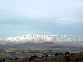
Mount Hermon (Arabic: جبل الشيخ or جبل حرمون / ALA-LC: Jabal al-Shaykh ("Mountain of the Sheikh") or Jabal Haramun; Hebrew: הר חרמון, Har Hermon, "Mount Hermon") is a mountain cluster constituting the southern end of the Anti-Lebanon mountain range. Its summit straddles the border between Syria and Lebanon and, at 2,814 m (9,232 ft) above sea level, is the highest point in Syria. On the top, in the United Nations buffer zone between Syrian- and Israeli-occupied territories, is the highest permanently manned UN position in the world, known as "Hermon Hotel". The southern slopes of Mount Hermon extend to the Israeli-occupied portion of the Golan Heights, where the Mount Hermon ski resort is located. A peak in this area rising to 2,236 m (7,336 ft) is the highest elevation in Israeli-controlled territory.
Contents
- Mount hermon un facility on nephilim ground
- Map of Mt Hermon
- Geography
- Arab Israeli conflict
- Ski resort
- References
Map of Mt Hermon
Geography
Mount Hermon is actually a cluster of mountains with three distinct summits, each about the same height. The Anti-Lebanon range, of which the Hermon range constitutes the southernmost part, extends for approximately 150 km (93 mi) in a northeast-southwest direction, running parallel to the Lebanon range on the west. The Hermon range covers an area of about 700 km2 (270 sq mi) of which about 70 km2 (27 sq mi) are under Israeli control. Most of the portion of Mount Hermon within the Israeli-controlled area constitutes the Hermon nature reserve. The entire relatively narrow range, with the Lebanon-Syria boundary along its spine, extends from 25km northeast of Mt. Hermon to 45km southwest of it.
The mountain forms one of the greatest geographic resources of the area. Because of its height it captures a great deal of precipitation in a very dry area of the world. The Jurassic limestone is broken by faults and solution channels to form a karst topography. Mount Hermon has seasonal winter and spring snow falls, which cover all three of its peaks for most of the year. Melt water from the snow-covered mountain's western and southern bases seeps into the rock channels and pores, feeding springs at the base of the mountain, which form streams and rivers. These merge to become the Jordan River. Additionally, the runoff facilitates fertile plant life below the snow line, where vineyards and pine, oak, and poplar trees are abundant.
The springs, and the mountain itself, are much contested by the nations of the area for the use of the water. Mount Hermon is also called the "snowy mountain," the "gray-haired mountain", and the "mountain of snow". It is also called "the eyes of the nation" in Israel because its elevation makes it Israel's primary strategic early warning system.
Arab-Israeli conflict
During the Six day war in June 1967, a part of Mount Hermon in Syria was captured by Israel. It was regained by Syria on October 6, 1973, the first day of the Yom Kippur War, following the First Battle of Mount Hermon. Israel recaptured both the formerly Israeli-occupied sector and the pre-Yom Kippur War Syrian-controlled sector on October 21, 1973, during Operation Dessert. The pre-Yom Kippur War Syrian-controlled sector was returned to Syria after the war.
The Israeli-occupied sector of the mountain became patrolled by the Israel Defense Forces and the Israel Police, and the Israeli Security Forces have maintained a strategic observation post for monitoring Syrian and Lebanese military activity near Mitzpe Shlagim ("Snow Lookout"), which is at an elevation of about 2,224 m (7,300 ft). Its neighboring peak, at 2,236 metres (7,336 ft), is the highest elevation in Israeli-occupied territory.
Since the onset of Syrian Civil War, the Syrian-controlled Hermon has continued to be under pro-Assad forces, though clashes have sporadically erupted on the mountain range and spilled into Lebanon and the Israeli-occupied portion. Most notably the Islamist rebel factions of Jaish al-Haramoun took part in the fighting on the Southern slopes of the mountain.
Ski resort
Since 1981, when the Golan Heights Law was passed, the Israeli-occupied portion of the Golan Heights has been governed under Israeli law. Mount Hermon hosts the only ski resort in territory held by Israel, including a wide range of ski trails at novice, intermediate, and expert levels. It also offers additional winter family activities such as sledding and Nordic skiing. Those who operate the Hermon Ski area live in the nearby Israeli settlement of Neve Ativ and the Druze town of Majdal Shams. The ski resort has a ski school, ski patrol, and several restaurants located at either the bottom or peak of the area. In 2005, the Syrian government had plans to develop a 15-billion-dollar ski resort on the slopes of the mountain.