
Elevation 2,374 m | Prominence 1,252 m | |
 | ||
Similar Mount Constance, Mount Anderson, Buckhorn Mountain, Mount Townsend, Mount Olympus | ||
Mount Deception is a peak in the Olympic Mountains in the U.S. state of Washington. It is in Olympic National Park on the Olympic Peninsula.
Contents
Map of Mt Deception, Washington, USA
DescriptionEdit
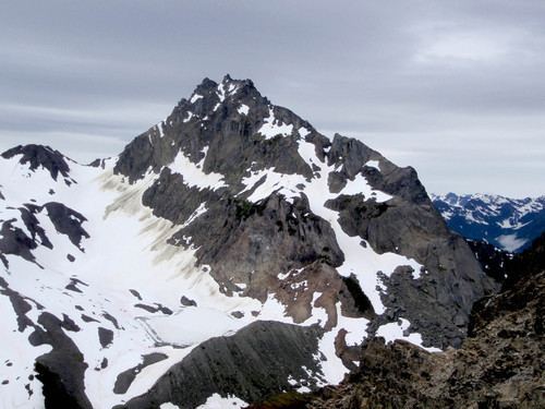
At 7,788 feet (2,374 m) high Mount Deception is the second highest peak of the Olympic Mountains, after Mount Olympus. It is the highest peak of the eastern Olympics. Mount Deception's prominence is 4,108 feet (1,252 m), making it the 17th most prominent peak in Washington. Its nearest higher peak is Mount Olympus at 21.79 mi (35.07 km) to the west.
Mount Deception is located in the northeast portion of the Olympics Mountains just northeast of Mount Mystery between Deception Creek and Royal Creek. The region is known as Royal Basin and includes the upper reaches of Royal Creek. Mount Deception lies at the head of Royal Basin. This location puts it in the rain shadow of the Olympics, resulting in far less precipitation than Mount Olympus and the western Olympics receive. Although Mount Deception is the highest peak in the eastern Olympics, it is not visible from Seattle.
Radiating northward from the shoulders of Mount Deception are The Needles, Mount Clark (7,528 ft or 2,295 m), Mount Walkinshaw (7,378 ft or 2,249 m), and the northeasterly running spur known as Gray Wolf Ridge. To the east and south are Mount Fricaba, Hal Foss Peak, Mount Mystery, and Little Mystery. Two small glaciers hug the mountain's north-facing basalt slopes.
Mount Deception sits on the boundary between the drainage basins of the Dungeness River, to the north, and the Dosewallips River, to the south and east. Deception Creek, a tributary of the Dosewallips River, drains the southern slope of Mount Deception. Gray Wolf Pass is located about 1 mile (1.6 km) west of Mount Deception. The pass connects the Dungeness and Dosewallips drainage basins.
HistoryEdit
Mount Deception had been given the name Mount Holmes by the Seattle Press Expedition in honor of John H. Holmes of the Boston Herald. Later G.A. Whitehead of the U.S. Forest Service renamed it Mount Deception due to the difficulty mountaineers had in locating climbing routes on the often cloud-covered peak.
RecreationEdit
Unlike the peaks of Gray Wolf Ridge, which are scalable for fit and determined day hikers, mountaineering skills are necessary for Mount Deception itself. While not a particularly technical climb it is steep and exposed. If a climber falls and does not arrest immediately, loose rock and rotten snow may make it difficult to stop falling for some distance. Fatalities have occurred on Mount Deception and the National Park Service recommends climbers be experienced in self-arrest skills, rock climbing, and route-finding.
The adjacent Needles are typically regarded as providing better, and somewhat more difficult, mountaineering objectives in the Royal Basin area.