
Easiest route Scramble First ascent 1892 Province British Columbia | Elevation 2,599 m Prominence 418 m Mountain range Canadian Rockies | |
 | ||
Similar Wapta Mountain, Mount Stephen, Mount Field, The President, Mount Bosworth | ||
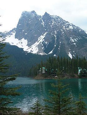
Mount Burgess, 2,599 m (8,527 ft), is a mountain in Yoho National Park and is part of the Canadian Rockies. It is located in the southwest buttress of Burgess Pass in the Emerald River and Kicking Horse River Valleys.
Contents
Map of Mount Burgess, Columbia-Shuswap A, BC, Canada
History
It was named in 1886 by Otto Koltz after Alexander MacKinnon Burgess, the Deputy Minister of the Interior at the time.
In 1892, James J. McArthur was the first to ascend this mountain. He was completing a survey of the lands adjacent to the Canadian Pacific Railway.
In 1909, geologist Charles D. Walcott discovered the Burgess Shale deposit of fossils with fine details on Mount Burgess. The Burgess Shale is a black shale fossil bed (Lagerstätte) named after nearby Burgess Pass, in which are found new and unique species, many in fact constituting entire new phyla of life, and even today some of these unique species have proven impossible to classify. The fossils are especially valuable because they include appendages and soft parts that are rarely preserved.
The mountain has two summits. The lower north summit was named Walcott Peak in his honour.
Between 1954 and 1971, Mount Burgess was featured on the back of the Canadian ten-dollar bill. It is still informally called the "Ten Dollar Mountain" as a result.
In 1984, UNESCO declared the area a World Heritage Site.