
Elevation 1,049 m | ||
 | ||
Mountain range Explorers Range, Blue Mountains Parent ranges Explorers Range, Blue Mountains Similar Mount Boyce, Mount Hay, Mount Bindo, Mount Solitary, Mount York | ||
Mount Banks, a mountain within the Explorers Range of the Blue Mountains Range that is a spur off the Great Dividing Range, is located within the Blue Mountains National Park, approximately 100 kilometres (62 mi) west of Sydney in New South Wales, Australia. Mount Banks is located 8 kilometres (5.0 mi) from the nearest residential area, Mount Tomah, has an elevation of 1,049 metres (3,442 ft) AMSL, and can be accessed relatively easily via the Bells Line of Road.
Contents
- Map of Mount Banks Blue Mountains National Park NSW 2787 Australia
- Blue mountains national park bush walk mount banks
- Geography
- Description
- Activities
- References
Map of Mount Banks, Blue Mountains National Park NSW 2787, Australia
Blue mountains national park bush walk mount banks
Geography
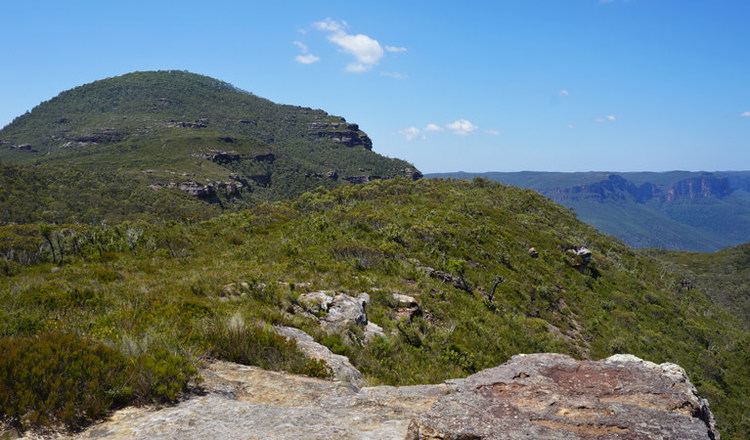
Mount Banks is part of the Explorers Range, which is located along the northern escarpment of the Grose Valley in the Blue Mountains National Park. The Explorers Range starts at Bells Line of Road and extends along the northern edge of the Grose Valley. Mount Banks is the first noticeable peak along the range and is found about 2 kilometres (1.2 mi) from Bells Line of Road. It was named Mount Banks in 1804 by the explorer George Caley, who had worked for the botanist Sir Joseph Banks. Caley who was the first European to reach Mount Banks.
The distinctive thing about Mount Banks is the way the terrain and vegetation change radically approaching the top of the mountain. For the first two-thirds of the walk, the terrain is the standard sandstone of the Sydney and Blue Mountains regions, with a thin, rough scrub. After this, however, there is a basalt cap which gives rise to a richly vegetated environment with grass and a canopy. Views can be had on the lower slopes of the mountains but there is no view at the top, unless the walker edges down the slope towards the escarpment, at which point there are views of the Grose Valley.
Description
An unsealed road goes from Bells Line of Road to a picnic area about 1 kilometre (0.62 mi) from the junction. At this point, vehicular access comes to an end. From the picnic area, a walking track makes its way approximately 1 kilometre (0.62 mi) to the top of Mount Banks, where there is a trigonometric station. This is 1,062 metres (3,484 ft) above sea level. From this point on, there is a fire trail that follows the Explorers Range before terminating above Zobel Gully. According to the topographic map, there is an abandoned mine in Zobel Gully, but there is no track to it.
Activities
The area is popular for bushwalking, with extensive views of the Grose Valley from the lower slopes of the mountain and from the fire trail where it goes close to Banks Wall, about 1 kilometre (0.62 mi) south of the mountain. Photography is also popular because of the extensive views. There is no authorised camp site at Mt. Banks and camping at this fragile world heritage site is strictly prohibited.