
Elevation 1,406 m | Last eruption 0.2 Ma Easiest route Hiking | |
 | ||
Similar Mt Omuro, Mount Tanzawa, Mount Daibosatsu, Mount Azumaya, Mount Kobushi | ||
Welsh terrier in the mount amagi of izu
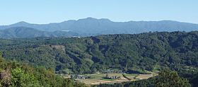
Mount Amagi (天城山, Amagi-san) is a range of volcanic mountains in central Izu Peninsula in Shizuoka Prefecture, Japan, forming the border between Izu City and Higashi-Izu Town. It is also referred to as the Amagi Mountain Range (天城連山, Amagi Renzan).
Contents
- Welsh terrier in the mount amagi of izu
- Map of Mount Amagi Jizodo Izu Shizuoka Prefecture 410 2515 Japan
- References
Map of Mount Amagi, Jizodo, Izu, Shizuoka Prefecture 410-2515, Japan
The Amagi mountains have several peaks, the tallest of which are Bansaburōdake (万三郎岳) at 1,406 metres (4,613 ft), Banjirōdake (万二郎岳) at 1,300 metres (4,300 ft), and Tōgasayama (遠笠山) at 1,197 metres (3,927 ft).
There are several hiking routes to the top. Flora in the area include rhododendrons, Japanese andromeda, stewartia monadelpha and Siebold's beech.
Many ships of the Imperial Japanese Navy were named after it, including a corvette, a battlecruiser and an aircraft carrier.
Amagi is listed as one of the 100 Famous Japanese Mountains in a book composed in 1964 by mountaineer/author Kyūya Fukada.