
Mountain type Volcanic Prominence 491 m Easiest route Hiking | Elevation 1,252 m | |
 | ||
Translation big mountainrain mountainguardian of the land mountain (Japanese) Pronunciation [oːjama][aɸuɽijama][kunimijama] Topo map Geographical Survey Institute 25000:1 大山50000:1 東京 Similar Mount Tō, Mount Tanzawa, Mount Hiru, Sannoto, Mount Ashigara | ||
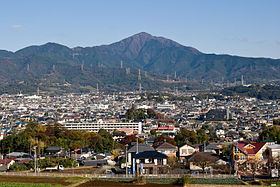
Mount Ōyama (大山, Ō-yama), also Mount Afuri (阿夫利山 or 雨降り山, Afuri-yama) or Mount Kunimi (Kunimi-yama), is a 1,252 metres (4,108 ft) high mountain situated on the border of Isehara, Hadano and Atsugi in Kanagawa Prefecture, Japan. Together with Mount Tanzawa and other mountains in the Tanzawa Mountains it forms the Tanzawa-Ōyama Quasi-National Park. Mount Ōyama is a popular sightseeing spot in Kanagawa Prefecture.
Contents
- Map of Mount C58Cyama Oyama Isehara Kanagawa Prefecture 259 1107 Japan
- Geology
- Holy mountain
- Sightseeing
- References
Map of Mount %C5%8Cyama, Oyama, Isehara, Kanagawa Prefecture 259-1107, Japan
Geology
The mountain is made from non-alkali mafic rock. The rock is 7-15 million years old. The rock was extruded on the sea floor during the Neogene and then pushed up and onto the island of Honshu when the Izu-Bonin-Mariana Arc collided with the rest of Japan.
Holy mountain
Mount Ōyama has long been regarded as a holy mountain and object of worship. Religiously motivated mountain climbing has been practiced since the Hōreki era (1751–1764) and the various paths leading there were called Ōyama Kaidō (大山街道, Ōyama Kaidō). Today this name survives as the pseudonym of Route 246.
At the top of the mountain is the head office of the Ōyama-Afuri Shrine (大山阿夫利神社, Ō-yama-afuri Jinja). Lower down the mountain is the lower shrine and the Ōyama-dera (大山寺). Afuri refers to the high amount of rain and clouds associated with the mountain. Farmers pray at Ōyama-Afuri Shrine to the rain god.
The mountain is also known as the Guardian of the Land (Kunimi-yama).
Sightseeing
A bus connects Isehara Station on the Odakyu Odawara Line with the cable car station at the foot of the mountain. A narrow road runs directly between the town areas and the cable car station. The cable car starts from next to Ōyama-dera and climbs to the top station. The top station is not far from the lower Afuri Shrine. Hiking from there it takes about 1.5 hours to climb to the top of the mountain.
Tofu and spinning tops are well-known local products. The Ōyama Tofu Festival takes place every March. The Ōyama mountain climbing Marathon also takes place in March between Isehara Station and the lower shrine. The course is over 9 kilometres (5.6 mi) long and includes an altitude difference of over 650 metres (2,130 ft). Possible access points for an ascent are the cable car terminus, the temple Hinatayakushi (日向薬師, hinatayakushi) in Isehara, Minoge (蓑毛, minoge) and the Yabitsu ridge (ヤビツ峠, yabitsu-tōge) in Hadano.