
- average 23 cu ft/s (1 m/s) | ||
 | ||
- elevation 97 ft (30 m) approximate using MapMyRun - coordinates Location of the USGS Hydrologic Unit, .4 mi downstream from diversion from Charles River. - elevation 55 ft (17 m) approximate using MapMyRun | ||
Mother Brook is a stream that flows from the Charles River in Dedham, Massachusetts, to the Neponset River in the Hyde Park section of Boston, Massachusetts. Mother Brook was also known variously as East Brook and Mill Creek in earlier times. Digging the brook made Boston and some surrounding communities an island, accessible only by crossing over water, making Mother Brook "Massachusetts' Panama Canal."
Contents
- Map of Mother Brook Dedham MA USA
- OriginsEdit
- Early millsEdit
- Industrialization of Mother BrookEdit
- 19th centuryEdit
- Conflict with Charles River MillsEdit
- 20th century and the decline of industryEdit
- PollutionEdit
- First privilegeEdit
- Second privilegeEdit
- Third privilegeEdit
- Fourth privilegeEdit
- Fifth privilegeEdit
- FloodsEdit
- 1938 floodEdit
- Drownings and rescuesEdit
- Other eventsEdit
- CleanupsEdit
- BridgesEdit
- RecreationEdit
- Works citedEdit
- References
Map of Mother Brook, Dedham, MA, USA
The portion of the brook dug by English settlers has been called the first man-made canal in the United States. Mother Brook was important to Dedham as its only source of water power for mills, from 1639 into the early 20th century.
Today, Mother Brook is part of a flood-control system that diverts water from the Charles River to the Neponset River. The brook's flow is under the control of the Massachusetts Department of Conservation and Recreation and is used for flood control on the Charles. There are three remaining dams on the stream, plus a movable floodgate that controls flow from the Charles into Mother Brook.
The brook has given its name to the modern day Mother Brook Community Group, the Mother Brook Arts and Community Center, Riverside Theatre Works, and the erstwhile Mother Brook Club and Mother Brook Coalition.
OriginsEdit
Dedham, Massachusetts was first settled in 1635 and incorporated in 1636. The settlers needed a mill for grinding corn. Wind mills had been tried, but the wind was too unreliable, and hand mills took too much effort. The closest mill was in Watertown, some distance away.
Abraham Shaw who, like many other Dedhamites, came from Watertown, arrived in Dedham in 1637. He was granted 60 acres (24 ha) of land as long as he erected a watermill, which he intended to build on the Charles River near the present day Needham Street bridge. Every man in the town was required to bring the millston to Dedham from Watertown. Shaw died in 1638 before he could complete his mill, however.
Although the initial settlement was adjacent to the Charles, in this vicinity it is slow-moving, with little elevation change that could provide power for a water wheel. A small stream, then called East Brook, ran close by the Charles River, about 100 rods (1,600 feet; 500 metres) from present day Washington Street behind Brookdale Cemetery, and emptied into the Neponset River. In the spring, the Charles would occasionally flood into a swamp at Purchase Meadow between its banks and East Brook. Additionally, East Brook had an elevation change of more than 40 feet on its run from near the early Dedham settlement to the Neponset River, while the Charles and the Neponset have an elevation change of more than 60 ft (18 m), which was sufficient to drive a water mill. The drop in the first mile alone is 45 ft (14 m).
A year after Shaw's death the Town was still without a mill. A committee was formed and it was determined that water could be diverted from the Charles, by way of a canal, to East Brook, providing the needed water flow. The 4,000 foot ditch was ordered to be dug at public expense by the Town on March 25, 1639. There is no record of who dug it or how long it took, although Whiting family history claims it was done by Nathaniel Whiting. The first water ran through it on July 14, 1641, and has been known as Mother Brook since at least 1678.
Early millsEdit
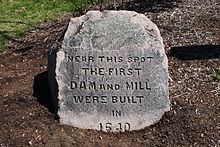
The Town also offered an incentive of 60 acres of land to whoever would construct a corn mill, as long as the mill was ready to grind corn by "the first of the 10th month"[i.e. December]. The first corn mill was erected in 1641 by John Elderkin, a recent arrival from Lynn, at a dam on East Brook next to the present day Condon Park and near the intersection of Bussey St and Colburn St. Elderkin had previously built a mill in Lynn and, in 1642, only months after opening the mill, moved out of town. This was the first public utility in the nation. Early settlers could grind their corn at the mill, and in return paid a tithe to help maintain the mill. The Town relinquished rights to the brook in 1682 and placed an historical marker on the site in 1886.
In 1642, Elderkin sold half of his rights to Whiting and the other half to John Allin, Nathaniel Aldis, and John Dwight. They operated the mill "in a rather stormy partnership" until 1649 when Nathaniel Whiting became the sole owner. The Town was displeased with the "insufficient performance" of the mill under Whiting's management. In 1652, Whiting sold his mill and all his town rights to John Dwight, Francis Chickering, Joshua Fisher, and John Morse for 250 pounds, but purchased it back the following year. Whiting and five generations of his descendants ran their mill from 1641 until 1823, when it was sold.
In January 1653 the Town offered land to Robert Crossman if he would build a mill on the Charles where Shaw had originally intended. Crossman refused, but Whiting was so displeased by the prospect of a second mill that he offered to sell his mill back to the Town for 250 pounds. Whiting's performance did not improve, however, and the town wanted an alternative. Daniel Pond and Ezra Morse were then given permission by the Town to erect a new corn mill on the brook above Whiting's, so long as it was completed by June 24, 1665.
Whiting was upset by the competition and, "never one to forgive and forget, Whiting made something of a crusade of opposition" to the new mill. Records show that the Town spent "considerable time" trying to resolve the issue. After meeting with the Selectmen, both agreed to live in peace and not interfere with the business of the other.
Two years later Morse was instructed to not hinder the water flow to such an extent that it would make milling difficult for Whiting, but Whiting was also told to repair leaks in his own dam. Trouble and disputes, including a lawsuit, continued between the two until, in 1699, the Morse dam at present day Maverick Street was removed, and Morse was given land at Tiot in compensation. This seems to have been Morse's idea.
The next mill was constructed in 1682 at Mill Lane. Originally requested by Jonathan Fairbanks and James Draper, the privilege was granted to Whiting and Draper instead. A condition was attached to this permission, however, that if the Town wanted to erect a corn mill on the brook that they may do so, unless Draper and Whiting did so at their own expense. This mill, like the one above it, was held by the descendants of Nathaniel Whiting for 180 years. One of Whiting's mills burned in 1700, and so the Town loaned him 20 pounds to rebuild.
At some point in the 1700s a new leather mill was constructed by Joseph Lewis at the site of the old Morse dam. A fourth mill was established, at present day Stone Mill Drive, just down stream from the third in 1787. For a short period of time it produced copper cents, and then was used to manufacture paper.
Industrialization of Mother BrookEdit
Eventually, dams and mills were constructed at five locations called "privileges" in Dedham and in what is now the Readville section of Hyde Park, which was originally part of Dedham. Mother Brook provided water power at various times for industrial mills of several types, for the manufacture of cotton, wool, paper, wire, and carpets. They also produced corn, fulled cloth, stamped coins, sawed lumber, cut and headed nails, manufactured paper, wove cloth, and leather. There were mills operating on Mother Brook until some time in the 20th century. At least one mill located on Mother Brook was converted from water power to steam as an energy source, but continued to use the brook for cooling the steam machinery.
19th centuryEdit
In the 1800s, as the region and country became more prosperous, mills began to be used for the first time to produce goods not used solely by Dedhamites and those in the immediate area.
The leather mill was replaced in 1807 by the Norfolk Cotton Manufactory which built a large wooden mill on the site. The mill spun imported bales of cotton, which was then put out to be woven. The fabric was then returned to the mill, finished, and shipped out. From 1808 through the next decade, the company advertised for labor in the local papers as the work required more manpower than the part-time grist and saw mills that were on the brook before.
It was a prosperous company, esteemed by the community, and the annual meetings of the company were marked by festivities. The War of 1812 brought ruin to the company, however, and the mill was purchased by Benjamin Bussey, "a man of excellent business capacity," in 1819 for a sum far below cost. Bussey also purchased a mill on the street that now bears his name from the Dedham Worsted Company only three years after they opened. It was said that the factories, dye houses, dwellings, and other buildings associated with the operation "of themselves constitute a little village."
The fourth privilege was used for a variety of purposes in the 19th century, including copper cents, paper, cotton, wool, carpets, and handkerchiefs. In the 1780s another mill, connected by the same wheel, was constructed on the site to produce wire for the new nation's nascent textile industry. The first mill on this site burned in 1809, but was rebuilt with a new raceway and foundation.
The second mill began producing nails in 1814, and five years later its owner, Ruggles Whiting of Boston, sold it to the owner of the first mill, George Bird, who began using the whole site to manufacture paper. In 1823 it switched to cotton, using the machinery of the former Norfolk Cotton Company. In 1835 a new stone mill was erected. It stands today, and was converted into a condominium complex in the 1980s. Unlike the other mills, which were constructed in a strictly utiliatrian style, this factory boasted a date stone reading "1835" and a dome-roofed cupola over the mill bell. Together they stood as a testament to the primacy of the mills in the neighborhood.
In 1814 a fifth privilege was granted in what was then Dedham, but is today the Readville neighborhood in Hyde Park. Readville, known then as Low Plain, was settled in the same year when the Dedham Manufacturing Company built a mill there.
During this time period the owners of mills downstream also complained that the Norfolk Cotton Manufactory did not provide enough water downstream for them to use. The complaints continued, despite the creation of a committee in 1811 to look into the matter, until Benjamin Bussey bought the Norfolk Cotton Manufactury in 1824. Agreement was made then on the level of the water, and was marked by drill holes in rocks along the banks still visible in 1900.
In 1870 the Merchant's Woolen Company was the largest taxpayer in town and owned two houses on High Street, five on Maverick, ten on Curve, and two "long houses" on Bussey. These houses were rented to employees. From Mother Brook and the Neponset River out to the Boston Harbor, it was estimated that there was between $2,000,000 and $5,000,000 worth of manufacturing property along the banks in the 1886.
Conflict with Charles River MillsEdit
As Dedham became industrialized and its economic activity increasingly dependened on its water power, so did other communities in the Charles River valley. This led to conflict between the mills on Mother Brook and those using the Charles River downstream from the diversion to Mother Brook. As early as 1767, mill owners in Newton and Watertown petitioned officials for relief from the Mother Brook diversion. A sill was installed to determine the percentage of water diverted into Mother Brook and the percentage to remain in the Charles.
In 1895 it was said that Mother Brook was the
most audacious attempt of robbery ever recorded in the Commonwealth of Massachusetts. It was the effort made by Dedham... to actually steal the river Charles. ... The bold pirates built a canal from the headwaters of the Charles across to the Neponset river, and by widening and deepening this 'mother brook' they were gradually robbing their neighboring town of its beautiful waterway.
Because water diverted from the Charles River through Mother Brook increased the flow in lower sections of the Neponset River, mill owners on the Neponset joined with the Mother Brook mill owners in their defense of the diversion. After a special act of the Great and General Court the mill owners incorporated as the Mother Brook Mill-owners Association on September 1, 1809. Mill owners on the Charles had formed a similar corporation to advocate for themselves a few months earlier. They argued that deviating the flow of the Charles "from its natural course" into Mother Brook violated their rights, and that as a public resource that it deserved state protection.
The Mother Brook Mill-owners Association and their counterpart on the Charles went to the Supreme Judicial Court in March 1809, and petitioned for Commissioners of Sewers to determine the proper amount of water to be diverted into Mother Brook. The 1767 sill could not be located, and a new method was established. The Commission did not present its findings to the Court for 12 years, however, at which time the Mother Brook owners objected and the report of the Commissioners was set aside.
In 1825, after a court battle, it was determined that the previous agreement was no longer viable due to the length of time taken to file the report and evidence not considered at the time. Work on the issue resumed from 1829 to 1831, and the dispute was finally settled by an agreement among the mill owners in December 1831. This agreement established that one-third of the Charles River flow would be diverted to Mother Brook, and two-thirds would remain in the Charles for use by downstream owners. This agreement, which was reaffirmed in 1955, "brought peace to the valley" after decades of conflict.
In 1915 it was estimated that one-third of the water of the Charles River ran through the brook, while in 1938 it was said to be one-half. In 1993, an average of 51 million gallons per day flowed from the Charles into Mother Brook, although that flow can be altered depending on water levels further downstream.
20th century and the decline of industryEdit
In 1900, and even 1915, after "275 years of constant usefulness," the brook made up "the source of the principal business of the town [of Dedham]." Though the mills remained open into the 20th century, they were not immune from the larger economic forces at play. In the late 1800s they began "losing ground in the national economic picture, inexorably sliding into an increasingly marginal sourt of operation, and finally succumbing entirely to the slump which followed the First World War." By 1986 the cotton mills and brick factories that once lined the brook were "long-gone."
It was proposed in 1978 to use the three remaining dams on the bridge to generate hydroelectric power. In 2009 Dedham Selectmen proposed designating the brook as an historic waterway to better qualify for grants.
PollutionEdit
During the early 1900s, the state Board of Health began enforcing pollution regulations that prevented additional manufacturing enterprises from setting up along the brook, having "resolutely set its decision against the pollution of this stream." One plant was required to install an expensive filtration system to clean its liquid waste before dumping it in the waterway.
In 1910 the water being pumped by the Town of Hyde Park at Mother Brook was deemed unsafe for use without first boiling, and in 1911 that Town applied to be hooked up to the metropolitan water system. By 1944 the Neponset was said to be "loaded with putrefacation."
When marshlands were reclaimed in the 1960s it was for partially for the purposes of flood control. One of those reclaimed areas was where the Dedham Mall now stands, very near the headwaters of the brook. The runoff from that 150-acre (61 ha) development, however, flowed into the brook and then the Neponset, which could not handle the extra water during heavy rains.
An oil spill of 1,300 gallons was discovered near Milton Street in 1975, and gasoline was discovered bubbling into the brook in 1990. L. E. Mason Co. was fined $250,000 by the Environmental Protection Agency for dumping trichloroethylene into the brook from 1986 to 1994. The company was also known to dump zinc, fats, oils and greases into the waterway. During the 1990s a science teacher at Dedham High School and her chemistry students ran water quality tests on the brook. She found that water quality is good, though fecal coliform counts allow only partial body contact.
First privilegeEdit
The first privilege was located next to present day Condon Park, corner of Bussey St and Colburn St.
Second privilegeEdit
The second privilege was located at present day Maverick Street.
Third privilegeEdit
The third privilege was located at present day Saw Mill Lane.
Fourth privilegeEdit
The fourth privilege's first mill was located at present day Stone Mill Drive.
The fourth privilege's second mill was located at present day Stone Mill Drive.
Fifth privilegeEdit
The fifth privilege was located at located at the corner of Knight St. and River St. in Readville.
FloodsEdit
In 1886, waters flooded their banks and put the dams, and the one at Merchant's Mill especially, in danger of breaching. There were fears that a dam in Dover would give way, and the resulting rush of water would destroy the Dedham dam. Prior to this Merchant's Mill was considered impregnable. It was one of the greatest floods Dedham Centre had ever seen.
Streets in the Manor section of Dedham had water two to three feet deep when the brook flooded in March 1936. Rain and melting snow caused the Charles and Mother Brook to flood their banks in 1948, putting some parts of Dedham under water.
Ice chunks at two of the dams caused flooding in 1955. Firefighters sprayed high pressure water at the ice jam off Milton Street, and a crane scooped out debris from the dam and broke the ice at Maverick Street. The water level dropped two feet that day as a result.
Later that year, during the worst floods in New England's history, 150 people in Hyde Park had to evacuate their homes after flood waters from Mother Brook and the Neponset River collapsed preventative embankments. Mayor John Hynes led an inspection party to survey the damage. Roads, including the V.F.W. Parkway, were flooded in Dedham. That fall the state approved $2 million for flood control in Mother Brook and the Neponset. Another $2 million was approved by the Massachusetts House of Representatives in 1960.
A team of 120 men descended on Hyde Park at the junction of the Neponset and Mother Brook with 1,200 sandbags to prevent flooding in March 1958. The water was already threatening homes and roads in January of that year. At least "a couple hundred" residents along the Charles, Neponset, and Mother Brook had to be evacuated when those rivers flooded in 1968. The worst area in town was along Bussey St, along the brook.
1938 floodEdit
In 1938, while much of the Charles and Neponset Rivers were flooding their banks and causing $3,000,000 in damage, the area around Mother Brook was unharmed in the early days of the surge. Dams along the brook controlled the heavy flow of water which were said to be 15,000 cubic feet per second. It was close to the level of the 1936 flood, but six inches below the flood of 1920.
Scores of homes in low-lying areas eventually had their basements flooded, and the wooden bridge at Maverick Street was threatened. Sandbags, an oil truck, and granite slabs were placed on the bridge to keep it from washing away. The Boston Envelope Company, located next to the bridge, had their first floor flooded.
Three young men who tried to canoe down the Charles during the 1938 flood were overturned in a whirlpool and were swept down the swollen Mother Brook. They were saved after an East Street rescuer ran 500 yards and tossed them a garden hose.
Drownings and rescuesEdit
Over the years there have been a number of accidents on the brook, including some resulting who drowned. In December 1905, a 12-year-old boy named James Harnett drowned while skating across ice only half an inch thick on Mill Pond. His brother William, 17, rushed to save him, but both ended up in the water. The older brother was saved by a human chain of other skaters, while the younger boy's body was recovered by police an hour later.
An 8-year-old boy fell through the ice and was under water for 20 minutes in 1980. A passing motorist and three others dove in the brook, but were not able to locate him. A WHDH radio traffic helicopter broke the ice with its pontoons, allowing Boston firefighters to spot and recover David Tundidor's body. He was in a medically induced coma, but died four days later.
Others have been more fortunate, and were able to be rescued. After sneaking out of the house in July 1899, 13-year-old William Dennen dove off a bridge near his house on Emmett Ave to save the life of 7-year-old Mary Bouchard, who had fallen in. John F. McGraw, a 33-year-old Scottish immigrant, attempted suicide by drowning in the brook in 1916. After going over a dam and landing in shallow water, the father of three climbed onto shore and was taken to the psychiatric hospital for evaluation. Paul Flanagan, 23, survived for 3.5 hours in the water after his car plunged into the brook in February 1983. He was brought to Norwood Hospital with hypothermia and was later released.
Two boys claimed to have found a human leg in the brook in 1937, but police could not find either the leg or the body.
Other eventsEdit
In April 1878, a "balky horse" sent six people into the brook, but none were injured. A similar incident occurred in 1837 when a thirsty horse brought himself, the teamster driving him, and the load of paper he was carrying from the mills in Dedham to Braintree into the brook.
Moments after leaving Dedham Square for Forest Hills in 1911, a streetcar jumped the track on Washington Street and dangled 35 passengers over the brook. Only two minor injuries were reported. A cat was saved from a flooded culvert in 1938 by a team of neighborhood boys after the Dedham Fire Department was unable to do so. A 13-year-old boy, William Sullivan, was kneeling on a raft in 1956 behind Brookdale Cemetery when his friend accidentally shot him in the leg with a .32 caliber gun.
CleanupsEdit
After centuries of industrialization and dumping, Mother Brook became quite polluted. Cleanups have been organized by a number of groups in recent decades.
BridgesEdit
Today, after diverting from the Charles, Mother Brook immediately runs under a bridge on Providence Highway. When it was constructed, a tablet was erected on the bridge commemorating the brook. Shortly thereafter it runs under a culvert at the Dedham Mall before appearing again at the transfer station and running to the Washington Street Bridge. It then crosses under Maverick Street, Bussey Street, and Saw Mill Lane, sites of three old mills. After entering Hyde Park, it runs under bridges at River Street and Reservation Road, before merging with the Neponset.
Various improvements to the bridges have been proposed and carried out over the years by the Commonwealth of Massachusetts, the Town of Dedham, the City of Boston, and private interests.
RecreationEdit
A canoeist in 1893 wrote of his trip down the brook that upon entering from the Charles he
bid adieu to the flat marshlands and broad views of the farther river, for the little brook caries us thought varied scenery now by a barnyard with it lowing cattle, ducks splashing and dibbing in the water and a dilapidated old carryall backed into the stream, left to wash itself, and then into the cool woodlands, where we can almost touch the banks on either hand. And the green alder bushes arch over our heads, forming a cool and shady tunnel.
The water is so shallow that we see plainly the brilliantly colored pebbles on the bottom and daintly hued little fish darting hither and thither. it is a busy, brawling stream and hurries on to join the Neponset, industrioulsy turning the numerous mills on the way.
A public bath house was constructed in 1898 at a cost of $700. In 1907, afternoons on Tuesdays and Fridays were set aside for women's use. Girls 16 and under were allowed in free, while those older were charged 5 cents. The youngest member of the Parks Commission, J. Vincent Reilly, taught crowds of more than 200 how to swim. It burned down in 1923, and a proposal in 1924 to rebuild it was expected to receive an unfavorable recommendation from the Warrant Committee. The swimming area at present day Mill Pond Park was considered a perk of working at the Boston Envelope Company in 1936.
Future Supreme Court justice Louis D. Brandeis wrote to William Beltran De Las Casas, the Chairman of the Metropolitan Park Commission, in 1905, asking him to consider including the brook in the Metropolitan Park System of Greater Boston. He said "unique in the metropolitan district. It is quite like the Main woods." He added that if it was added, though it is separated from the rest of the parks, "the future interests of our metropolitan park system would in my opinion be greatly subserved." De Las Cas agreed with Brandeis, but the mill owners in the area threatened to sue to prevent the action, and the costs of taking it by eminent domain were high.
In 1915 it was said that well-kept gardens could be seen along both sides of the length of the brook. It was also a popular boating and bathing destination. In at least the 1930s and 1940s, the state Division of Fish and Game stocked the brook with trout for fishing. The banks were lined with fishermen during parts of 1941.
While Dedham had a Commissioner of Mother Brook during this time period, the Planning Board was responsible for the recreation aspects of the brook, appointing a special police officer and life-saver, and running swimming and diving competitions. The swimming competitions drew crowds of 800.
In 1968 the Metropolitan Park Commission applied for an "Open Spaces Grant" from the federal government, during which time part of the area near the headwaters were being drained to build the Dedham Mall. The Boston Natural Areas Fund conserved a lot along the brook in 1980 as "green relief from massed buildings and pavement." The City of Boston built a new park on Reservation Road in 1999, shoring up the banks of the brook while they worked. The project on the six acre site included a skateboard park, a landscaped nature area along the brook, and a cleanup of contaminants.
Today along the banks of the brook are walking trails, a picnic area, a canoe launch, Condon Park, a handicapped accessible playground, and more. The Mother Brook Community Group won a grant from Dedham Savings to turn the old Town Beach at the intersection of Bussey and Colburn Street into a passive park with an observation deck, benches, landscaping and a stone path. Mill Pond Park opened on July 12, 2014. The Community Group has also opened more areas of the brook back up to fishing, and the catches are safe to eat in moderate amounts.