
Country United States County Washington FIPS code 20-48450 Elevation 411 m Zip code 66958 Population 151 (2013) | Time zone Central (CST) (UTC-6) GNIS feature ID 0472873 Area 36 ha Local time Sunday 1:02 AM Area code 785 | |
 | ||
Weather 10°C, Wind SE at 11 km/h, 36% Humidity | ||
Morrowville is a city in Washington County, Kansas, United States. As of the 2010 census, the city population was 155.
Contents
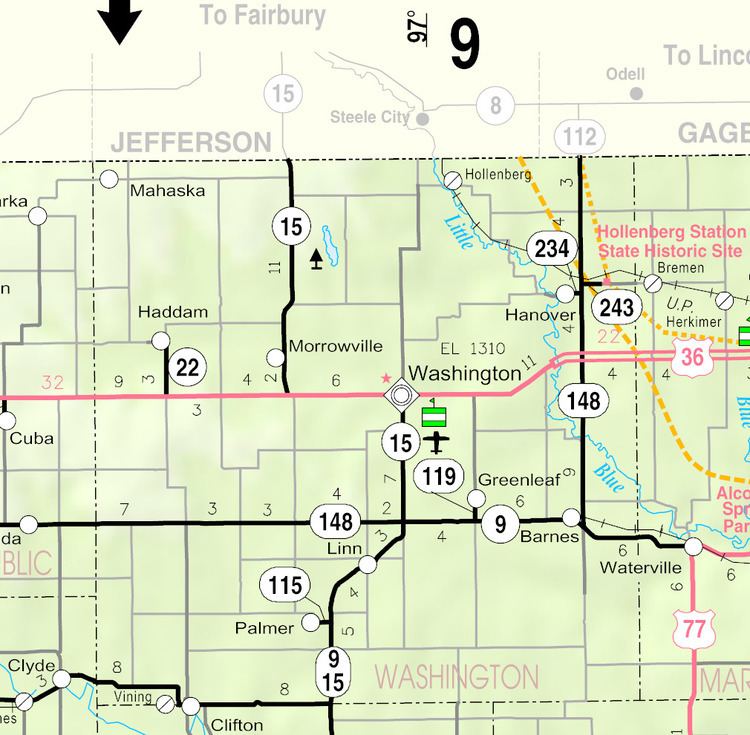
- Map of Morrowville KS 66958 USA
- History
- Geography
- Area attractions
- 2010 census
- 2000 census
- Education
- References
Map of Morrowville, KS 66958, USA
History
Morrowville was laid out and platted in 1884 when it was certain that the Missouri and Burlington Railroad would be extended to that point. It was named for its founder, James C. Morrow.
The first post office in Morrowville was established in 1884, but the post office was called Morrow Station until 1894.
Geography
Morrowville is located at 39°50′38″N 97°10′20″W (39.843829, -97.172337). According to the United States Census Bureau, the city has a total area of 0.14 square miles (0.36 km2), all of it land.
Area attractions
2010 census
As of the census of 2010, there were 155 people, 60 households, and 42 families residing in the city. The population density was 1,107.1 inhabitants per square mile (427.5/km2). There were 90 housing units at an average density of 642.9 per square mile (248.2/km2). The racial makeup of the city was 98.7% White and 1.3% from two or more races.
There were 60 households of which 38.3% had children under the age of 18 living with them, 65.0% were married couples living together, 1.7% had a female householder with no husband present, 3.3% had a male householder with no wife present, and 30.0% were non-families. 26.7% of all households were made up of individuals and 13.3% had someone living alone who was 65 years of age or older. The average household size was 2.58 and the average family size was 3.05.
The median age in the city was 40.4 years. 28.4% of residents were under the age of 18; 5.2% were between the ages of 18 and 24; 23.2% were from 25 to 44; 24.5% were from 45 to 64; and 18.7% were 65 years of age or older. The gender makeup of the city was 52.3% male and 47.7% female.
2000 census
As of the census of 2000, there were 168 people, 73 households, and 44 families residing in the city. The population density was 1,187.4 people per square mile (463.3/km²). There were 93 housing units at an average density of 657.3 per square mile (256.5/km²). The racial makeup of the city was 98.21% White, 1.19% Native American, and 0.60% from two or more races. Hispanic or Latino of any race were 0.60% of the population.
There were 73 households out of which 27.4% had children under the age of 18 living with them, 54.8% were married couples living together, 2.7% had a female householder with no husband present, and 38.4% were non-families. 38.4% of all households were made up of individuals and 26.0% had someone living alone who was 65 years of age or older. The average household size was 2.30 and the average family size was 3.09.
In the city, the population was spread out with 28.0% under the age of 18, 1.8% from 18 to 24, 25.0% from 25 to 44, 17.3% from 45 to 64, and 28.0% who were 65 years of age or older. The median age was 40 years. For every 100 females there were 90.9 males. For every 100 females age 18 and over, there were 95.2 males.
The median income for a household in the city was $26,786, and the median income for a family was $32,500. Males had a median income of $22,813 versus $16,250 for females. The per capita income for the city was $12,133. About 4.8% of families and 9.1% of the population were below the poverty line, including 15.9% of those under the age of eighteen and 7.4% of those sixty five or over.
Education
Haddam is served by USD 108 Washington County Schools. The Washington County High School mascot is Tigers.
School unification consolidated Morrowville and Haddam schools into Morrowville-Haddam schools in 1967. The high school was in Morrowville. The grade school in Haddam.
The Morrowville High School mascot was Morrowville Cougars.