
Country United States County Washington FIPS code 20-29400 Elevation 421 m Zip code 66944 Population 101 (2013) | Time zone Central (CST) (UTC-6) GNIS feature ID 0472865 Area 91 ha Local time Tuesday 8:22 AM Area code 785 | |
 | ||
Weather -6°C, Wind E at 10 km/h, 79% Humidity | ||
Haddam is a city in Washington County, Kansas, United States. It is named after Haddam, Connecticut. As of the 2010 census, the city population was 104.
Contents
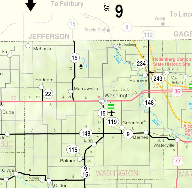
Map of Haddam, KS 66944, USA
History
Haddam was founded in 1869. It was named after Haddam, Connecticut. In 1874, the rival town of West Haddam merged with Haddam.
Geography
Haddam is located at 39°51′23″N 97°18′10″W (39.856335, -97.302865). According to the United States Census Bureau, the city has a total area of 0.35 square miles (0.91 km2), all of it land.
2010 census
As of the census of 2010, there were 104 people, 52 households, and 29 families residing in the city. The population density was 297.1 inhabitants per square mile (114.7/km2). There were 88 housing units at an average density of 251.4 per square mile (97.1/km2). The racial makeup of the city was 97.1% White, 1.0% Native American, and 1.9% from two or more races. Hispanic or Latino of any race were 1.0% of the population.
There were 52 households of which 17.3% had children under the age of 18 living with them, 44.2% were married couples living together, 5.8% had a female householder with no husband present, 5.8% had a male householder with no wife present, and 44.2% were non-families. 40.4% of all households were made up of individuals and 30.7% had someone living alone who was 65 years of age or older. The average household size was 2.00 and the average family size was 2.69.
The median age in the city was 52.8 years. 17.3% of residents were under the age of 18; 6.7% were between the ages of 18 and 24; 10.6% were from 25 to 44; 35.6% were from 45 to 64; and 29.8% were 65 years of age or older. The gender makeup of the city was 44.2% male and 55.8% female.
2000 census
As of the census of 2000, there were 169 people, 73 households, and 48 families residing in the city. The population density was 487.7 people per square mile (186.4/km²). There were 96 housing units at an average density of 277.0 per square mile (105.9/km²). The racial makeup of the city was 97.04% White, 1.18% Native American, and 1.78% from two or more races. Hispanic or Latino of any race were 0.59% of the population.
There were 73 households out of which 21.9% had children under the age of 18 living with them, 61.6% were married couples living together, 4.1% had a female householder with no husband present, and 34.2% were non-families. 34.2% of all households were made up of individuals and 21.9% had someone living alone who was 65 years of age or older. The average household size was 2.32 and the average family size was 2.96.
In the city, the population was spread out with 23.7% under the age of 18, 5.3% from 18 to 24, 20.1% from 25 to 44, 23.1% from 45 to 64, and 27.8% who were 65 years of age or older. The median age was 46 years. For every 100 females there were 128.4 males. For every 100 females age 18 and over, there were 101.6 males.
The median income for a household in the city was $20,000, and the median income for a family was $30,000. Males had a median income of $20,341 versus $14,375 for females. The per capita income for the city was $12,555. About 9.1% of families and 16.3% of the population were below the poverty line, including 26.2% of those under the age of eighteen and 3.4% of those sixty five or over.
Education
Haddam is served by USD 108 Washington County Schools. The Washington County High School mascot is Tigers.
School unification consolidated Morrowville and Haddam schools into Morrowville-Haddam schools in 1967. The high school was in Morrowville. The grade school in Haddam.
The Haddam High School mascot was Haddam Hounds.