
Country Area 39,492 Mayor Daniel Duglery | Elevation 207 m Region Auvergne Population 1,900/km2 | |
 | ||
Montluçon ([mɔ̃.ly.sɔ̃] is a commune in central France on the Cher river. It is the largest commune in the Allier department, although the department's préfecture is located in the smaller town of Moulins. Its inhabitants are known as Montluçonnais. The town is in the traditional province of Bourbonnais and was part of the mediaeval duchy of Bourbon.
Contents
- Map of Montluon
- Montluc on
- Geography
- Early history
- World War II
- Post World War II
- Air
- Road
- Rail
- City buses
- Sights
- Monuments
- Culture
- Twin towns sister cities
- Miscellaneous
- Personalities
- References
Map of Montluçon
Montluc on
Geography
Montluçon is located in the northwest of the Allier department near the frontier of the Centre and Limousin regions.
Montluçon is linked with surrounding regions and towns via four main road axes, plus the highway A71 from Orléans to Clermont-Ferrand; through a railway linking in the North Vierzon then Paris (3-5h). Formerly the canal de Berry linked Montluçon towards the north.
Montluçon is 106 kilometres (66 miles) south of Bourges, 340 km (211 miles) from Paris, 95 km (59 mi) from Clermont-Ferrand, 280 km (174 mi) (3h) from Lyon, 150 km (93 mi) (2h) from Limoges and 400 km (249 mi) from the Atlantic coast.
Montluçon is close to the Méridienne verte (an architectural project marking the Paris meridian) and to the Greenwich meridian.
Early history
Montluçon was built in the Middle Ages. The first mention of a place called Monte Lucii (Mont de Lucius) dates from the eleventh century. Guillaume, son of Archambaud IV of Bourbon, built the castle in a defensible position on a small rocky hill on a bend in the Cher River.
The town, which formed part of the duchy of Bourbon, was taken by the English in 1171, and by Philip Augustus in 1181; the English were finally driven out in the 14th century.
In the 14th century, Louis II de Bourbon re-built the castle and walls. Montluçon and other Bourbon lands reverted to the French crown in 1529, and Henry IV further improved the defenses.
Montluçon became the administrative seat of the area in 1791, then entered the industrial era thanks to the presence of coalpits 12 km (7 mi) distant in Commentry, the Canal de Berry in 1830 and the railway in 1864. These transport links allowed the import of ore and export of coal, wood and manufactured goods. The population grew from 5000 inhabitants in 1830 to 50 000 in 1950.
World War II
During the Second World War, the Germans occupied the Dunlop tyre plant (even though Montluçon was in the free zone) to exploit the research laboratory to synthesize rubber, since natural rubber could not be imported by the Nazis. The manufacturing of tyres for Luftwaffe aircraft was also of interest for the Nazis.
For this reason, the Allies bombed the site on 12–16 September 1943, as well as part of the nearby town Saint-Victor, causing 36 deaths and injuring more than 250 civilians.
A notable act of resistance occurred in the city on January 6, 1943 when a mob of citizens overran guards supervising a massive deportation of men to Germany in accordance with the Service de Travail Obligatoire (Obligatory Work Service) plan that sent able Frenchmen to fill vacancies in German factories during the war. All the men who were to be deported managed to escape into the countryside, evading the forced industrial service awaiting them in the Reich.
Post-World War II
Since 1945, traditional industry (blast furnaces and glassware) has declined. Today Montluçon has chemical industries, tyre manufacture (Dunlop), and electronics (Sagem), and more recently a technopole at La Loue was established for high-tech companies.
New Zealand-born Australian Nancy Wake, the most decorated woman of World War II, led her small army of resistance fighters in the countryside around Montlucon. On March 11, 2013 Nancy Wake's ashes were scattered in a small wood outside Montluçon. The ceremony was followed by a civic reception in the town. Wake died in August 2011, aged 98.
Air
There is a small airport 30 km (19 mi) from Montluçon (Montluçon - Guéret Airport) with flights mainly for Paris, and a smaller aerodrome in Montluçon itself (Montluçon - Domérat Aerodrome). The nearest international airports are Clermont-Ferrand Airport and Limoges Airport.
Road
Montluçon is linked to French and European road networks, by three major routes:
Rail
The Gare de Montluçon-Ville railway station is served by three main passenger rail lines.
City buses
Montluçon's local buses are run by Maelis.
Sights
The upper town, on the right bank of the Cher, consists of steep, narrow, winding streets, and preserves several buildings of the 15th and 16th centuries. The lower town, traversed by the Cher, is the industrial zone.
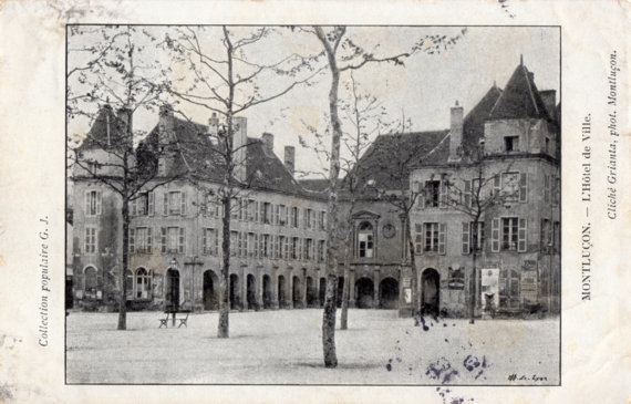
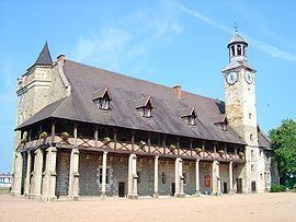
The church of Notre-Dame dates from the fourteenth century, the church of St Pierre partly from the 12th. The town hall, with a library, occupies the site of an old Ursuline convent, and two other convents are used as a college and hospital. Overlooking the town is the castle rebuilt by Louis II, Duke of Bourbon, and taken by Henry IV during the French Wars of Religion; it serves as a barracks.
Monuments
Culture
Twin towns – sister cities
Montluçon is twinned with:
Miscellaneous
Administration: Montluçon is a sub-prefecture and has courts, a board of trade arbitration, a chamber of commerce and several schools (general public, private, commercial).
Sport:
Personalities
Montluçon was the birthplace of: