
Prominence 387 m (1,270 ft) First ascent unknown Easiest route Hiking | Last eruption unknown Elevation 387 m | |
 | ||
Mountain type Stratovolcano (extinct) Similar Monte Grande, Rocha Estância, Pico da Antónia, Monte Gordo - Cape Ver, Topo da Coroa | ||
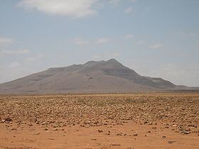
Monte Estância is a mountain in the southeastern part of the island Boa Vista in Cape Verde. At 387 m elevation, it is the island's highest point. It is located 23 km southeast of the island capital Sal Rei and not far from João Barrosa. The Atlantic Ocean is about 4 kilometres to the southeast and approximately 10 km to the west Monte Santo António or Pico, the island's second highest point. The mountain is entirely of volcanic origin. Almost the whole mountain area has no vegetation and is considered as the island's "countryside icon" and is seen throughout much of the island.
Map of Monte Est%C3%A2ncia, Cape Verde
It is part of a protected natural space in Cape Verde under the statute of natural monument, a reason that describes geological and geomorphical features. It also protects notable endemic plants and flowers and endangered birds. The protected area covers 736 ha and its boundary is 10.947 km long.