
Local time Wednesday 6:31 AM Number of airports 1 | ||
 | ||
Weather 21°C, Wind N at 29 km/h, 78% Humidity Points of interest Praia de Cabral, Praia do Estoril, Praia de Cruz, Praia d' Diante, Santa Isabel | ||
Sal rei boa vista cape verde islands
Sal Rei is a town on the northwestern coast of the island of Boa Vista in eastern Cape Verde. Sal Rei is the island's main urban settlement, and the seat of the Boa Vista Municipality. Its 2010 population was 5,778. Sal Rei has been island capital since the mid 1800s. The name of the settlement means "Salt King" in Portuguese. This name stems from when the island's main industry was salt production, saltpans lies north of the town, urban development now built into some of the saltpans.
Contents
- Sal rei boa vista cape verde islands
- Map of Sal Rei Cape Verde
- Cape verde sal rei boavista real adventures cabo verde with mia and lia e1
- Subdivisions
- History
- Climate
- Points of interests
- Sports
- Notable people
- References
Map of Sal Rei, Cape Verde
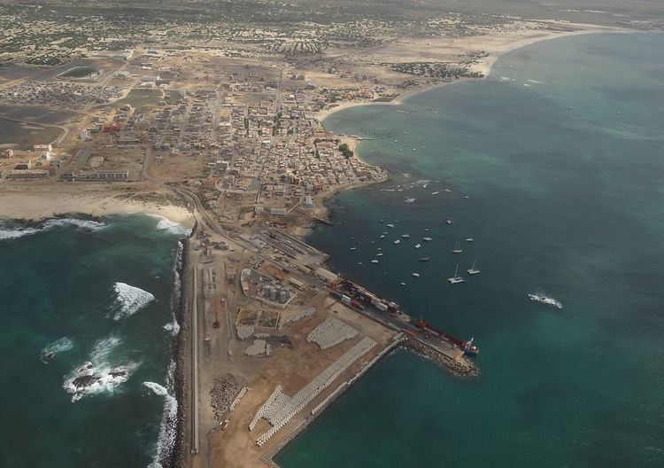
Sal Rei has a port on the bay and has ferry routes to the islands of Santiago (Praia), Sal (Santa Maria) and Maio (Vila do Maio). The small islet of Ilhéu de Sal Rei, which is mainly sandy and grassy, lies in the harbor.
Tourism is a major industry of Sal Rei in the area of Praia de Cabral, new hotels popped up in the south and southeast of town and more of it along with villas further north along the ocean even inside its saltpans.
Cape verde sal rei boavista real adventures cabo verde with mia and lia e1
Subdivisions
Subdivisions include the Historic center, the western portion (Oeste e Porto da Ilha), Ilhéu de Sal Rei, Barracas (also as Barracas ou Setor Norte) which is predominantly low-class, Praia de Cabral, the industrial northeast (Área Industrial), the eastern portion and the poorest portion of the city further east (sometimes as Bairro Novo do Este)
History
The town was founded in the saltpans of Boa Vista. In 1815 and 1817, the town was sacked by pirates, Forte Duque de Bragança was built on the nearby island to defend the town from further pirate attacks. In the early and mid 20th century the town was affected by emigration together with the whole island and Cape Verde which was led by droughts and famines.
The population has been growing large since the 1990s and gigantically since 2010 and recently surpassed the 6,000 mark, in percentage, the fastest growing town in Cape Verde. Windmills constructed roughly 3 to 4 kilometers north in 2008, also the town's perimeter road was completed. In the 2010s, the island's port started its enlargement which continues today and will be finished. Hurricane Fred struck the island in August 31, 2015, the island's cell service was cut off as the hurricane toppled a transmission tower in the north.
Climate
Sal Rei is in a desert climate zone as does the rest of the island. Its average rainfalll is 300 millimeters, the wettest is in August and the driest is in May without any rainfall The coldest is in January and the warmest is in July and August. Temperatures in July ranges from 22 a 30°C and 19 a 25°C in the winter.
Points of interests
Notable churches in town is Santa Isabel which serves as a parish seat covering the west of the island, it also has a square named after the church.
Sports
The football team in town are Sal-Rei FC and Académica Operária, teams that also serve the whole island includes Sporting Boa Vista. Once played in a small stadium west of the city, since February 2008, they play at the multi-use Estádio Municipal Arsénio Ramos roughly north of the city center.