
Mountain type Stratovolcano Easiest route Climbing | Elevation 1,394 m | |
 | ||
Similar Monte Grande, Monte Estância, Pico do Fogo, Topo da Coroa, Monte Fontainhas | ||
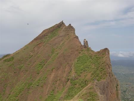
Pico da Antónia is Santiago's tallest mountain located in the central part of the island in Cape Verde. The mountain is part of the protected area Parque Natural de Rui Vaz e Serra de Pico de Antónia which includes other features as the Órgãos and Montes Tchota and Xexê. The mountain is entirely of volcanic origin. The towns Picos and Assomada lie close to the mountain. The area around the peak has been identified by BirdLife International as an Important Bird Area.
Map of Pico da Ant%C3%B3nia, Cape Verde
The mountain range forms a part of the municipalities of São Salvador do Mundo, São Lourenço dos Órgãos and Ribeira Grande de Santiago.
Its geology consists of the Pico da Antónia formation consisting of calcarenothorizonite rocks, it was formed between 3.3 to 2.3 million years ago during the Piacenzian and the Gelasian periods.
During the Ice Age from 15000 to 10000 BC, the elevation was above 1,500 meters, around 5000 BC, it mounted above 1,400 meters.