
Time zone EST (UTC−5) Highways Route 327 Route 364 Province Québec Population 619 (2011) | Constituted March 6, 1907 Postal code(s) J0T 2V0 Area 129.3 km² Local time Friday 6:54 PM Area code 819 | |
 | ||
Website www.municipalite.montcalm.qc.ca Weather -2°C, Wind SW at 5 km/h, 49% Humidity | ||
Montcalm is a municipality in the Les Laurentides Regional County Municipality of Quebec southeast of Mont-Tremblant. The main population centre in Montcalm is the village of Weir.
Contents
Map of Montcalm, QC, Canada
Demographics
Population trend:
Private dwellings occupied by usual residents: 308 (total dwellings: 663)
Mother tongue:
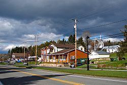
Weir
Weir (45°56′42″N 74°32′58″W) is an unincorporated village in Montcalm, accessible via Quebec Route 364. It is home to a satellite earth station for VSNL International Canada.
Weir is named after William Alexander Weir (1858-1929), a Quebec politician and judge.
References
Montcalm, Quebec Wikipedia(Text) CC BY-SA