
Isolation 5.51 km (18,100 ft) Topo map 21 M/16 Prominence 408 m | Translation Maple Mountain (fr) Elevation 1,048 m Province Québec Easiest route Hiking | |
 | ||
Similar Mont du Lac des Cygnes, Mont Richardson, Mount Gosford, Mont Jacques‑Cartier, Cap Trinite | ||
The Montagne des Érables, also known as Mont des Érables (), is a massif located in the Charlevoix-Est regional county municipality in the Charlevoix region of Quebec, Canada. It lies in the Hautes-Gorges-de-la-Rivière-Malbaie National Park and is home to l'Acropole des Draveurs, a popular hike in the province. It is accessible via the entrances to the park, the main one being located in Saint-Aimé-des-Lacs.
Contents
Map of Montagne des %C3%89rables, Mont-%C3%89lie, QC, Canada
Etymology
The mountain (along with many other geographic features and manmade installations in the park), whose name translates to "Maple Mountain," takes its name from the unique presence of maples juxtaposed with the tundra.
Geography
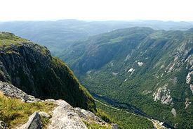
The massif contains the Acropole des Draveurs (Raftsmen's Acropolis), a rock face of the mountain, at an elevation higher than 800 m (2,600 ft).
Hiking
In order to reach the trails to l'Acropole, hikers must take a bus from the reception. The hike is 10 km round trip with an elevation gain of approximately 800 m (2,600 ft). The route is relatively gradual, allowing hikers an unintimidating hike without sudden terrain changes.