
Population 2,534 (2013) | Local time Friday 8:08 AM | |
 | ||
Weather -12°C, Wind E at 8 km/h, 85% Humidity Points of interest Castle Farms, Mount McSauba Road, Michigan Beach Park | ||
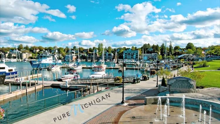
Ideal home for a boating enthusiast in charlevoix michigan
The Charlevoix region, located in Quebec, includes parts of the north shore of the Saint Lawrence River and the Laurentian Mountains region of the Canadian Shield. This dramatic landscape includes rolling terrain, fjords, headlands and bays; the region was designated a World Biosphere Reserve by UNESCO in 1989.
Contents
- Ideal home for a boating enthusiast in charlevoix michigan
- Map of Charlevoix MI 49720 USA
- Castle farms community attraction historical landmark in charlevoix michigan
- History
- Geography
- Natural history
- Ecological characteristics
- Socio economic characteristics
- References
Map of Charlevoix, MI 49720, USA
Castle farms community attraction historical landmark in charlevoix michigan
History
The region was named after Pierre François-Xavier de Charlevoix, a French Jesuit explorer and historian who traveled through this region in the 18th century. The community of La Malbaie was known as the first resort area in Canada. As early as 1760, Scottish noblemen Malcolm Fraser and John Nairn hosted visitors at their manors. For much of its history, Charlevoix was home to a thriving summer colony of wealthy Americans, including President William Howard Taft.
Geography
The Charlevoix region includes the regional county municipalities of Charlevoix-Est and Charlevoix.
Features of note include:
Natural history
The topography of this region was dramatically altered by a meteorite impact that occurred 350 million years ago creating the Charlevoix crater:
The impact created the forty-mile-wide crater that is the heart of Quebec's Charlevoix region, ranging from just west of Baie-Saint-Paul to just east of La Malbaie. Today, the area inside the crater is home to 90 percent of Charlevoix residents and is a very pastoral setting by comparison to what it could have been.
This area was subsequently reshaped by glaciation.
There have been several major earthquakes in the region in recorded history:
Ecological characteristics
Situated some 80 km east of Quebec City, Charlevoix Biosphere Reserve borders the Saint Lawrence River to the north. Extending from 5 to 1,150 metres above sea level, the area comprises agricultural areas, river ecosystems, estuarine tidal marshes and flats, coniferous and mixed forests, stunted vegetation (krummholz) and mountain tundra ecosystems.
Maple forests including paper birch (Betula papyriferae), alder (Alnus spp.) and elm (Ulmus spp.) and with an understory of sumac (Rhus typhina), Acer pensylvanicum and Cornus alternifolia; mixed fir (Abies sp.) forest with Corylus cornuta, Sambucus pubens and Taxus canadensis; boreal forests up to an altitude of 300 metres with fir and spruce (Picea spp.); estuarine tidal marsh and flats dominated by Scirpus americanus meadows including Zizania palustris, Sagittaria cuneata and S. latifolia; tundra with ericaceous zones consisting of Kalmia spp., Ledum groenlandicum; stunted vegetation community (krummholz) with Picea mariana and Abies balsamea; agro-ecosystems with cereals, fruits and legumes, and river ecosystems.
Animal species in the area include beluga whale (Delphinapterus leucas), wolf (Canis lupus), boreal woodland caribou (Rangifer tarandus caribou), North American cougar (Puma concolor couguar) and blue whale (Balaenoptera musculus).
Socio-economic characteristics
About 30,000 people live in the biosphere reserve (1988), which covers 457,000 hectares. In former times, the population of Charlevoix used to rely on the river and the sea, for example on coastal navigation, marine constructions and fisheries (e.g. beluga, eel).
Today, the economic landscape has diversified and major factors in the local economy are now forestry, silica mining, agriculture and tourism. The forest education centre ‘Les Palissades’ or the ecological center ‘Port-au-Saumon’ are important institutions for environmental education in the area. A five-year action plan (1999–2003) currently tries to promote the diverse goals of a biosphere reserve.