
Topo map NTS 031H/06 Elevation 390 m | Province Québec | |
 | ||
Similar Mont Yamaska, Mont Shefford, Mont Saint‑Grégoire, Mont Saint‑Bruno, Mont Mégantic | ||
Mont rougemont
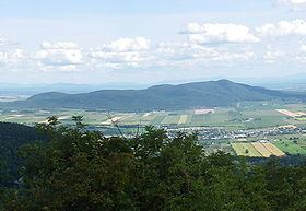
Mont Rougemont is part of the Monteregian Hills in southern Quebec. It is composed of igneous rock and hornfels. The summit stands 366 m (1,201 ft) above sea level. The mountain is mostly covered with sugar maple-dominated forest. Apple orchards and vineyards are cultivated on many of the lower slopes, and much of the fruit is used to make cider.
Contents
Map of Mont Rougemont, Saint-Damase, QC, Canada
Geology
The igneous material is composed almost entirely of mafic and ultramafic rock such as gabbro and olivine-bearing pyroxenite. Mont Rougemont might be the deep extension of a vastly eroded ancient volcanic complex, which was probably active about 125 million years ago. The mountain was created when the North American Plate moved westward over the New England hotspot, along with the other mountains of the Monteregian Hills. It forms part of the vast Great Meteor hotspot track.