
Prominence 330 m Parent peak Aiguille Verte | Elevation 3,820 m First ascent 9 July 1864 | |
 | ||
Easiest route South face and south-east ridge (PD) Similar Aiguille d'Argentière, Tour Noir, Aiguille Verte, Aiguille du Chardonnet, Aiguille de Triolet | ||
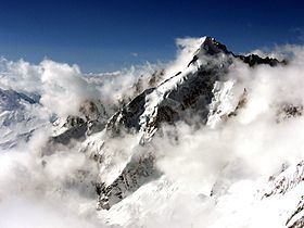
Mont Dolent (3,823 metres (12,543 ft)) is a mountain in the Mont Blanc massif which lies on the border between Italy, Switzerland and France.
Contents
Map of Mont Dolent
As a mountain, Mont Dolent is regarded as the tripoint between Italy, Switzerland and France, although the tripoint itself lies at 3,749 metres, less than 100 metres north-west of its summit.
The first ascent of the mountain was made on 9 July 1864 by A. Reilly and Edward Whymper with guides Michel Croz, H. Charlet and M. Payot. Whymper described the ascent in Scrambles amongst the Alps:
Mont Dolent has four faces, offering good quality snow and ice climbs of various levels of difficulty. However the only straightforward route to the summit (graded PD) is on its southern flank via the Glacier de Pre de Bar, finishing along a short and exposed stretch of the south-east ridge. The Fiorio Bivouac Hut (also known as Refuge Bivouac du Dolent) provides the closest start point for this four-hour ascent from the Italian side. The next easiest route of ascent(graded AD) is via the mountain's east ridge, starting from the similarly-named Bivouac du Dolent (la Maye) hut on its Swiss side.