
First ascent 10 July 1906 | Elevation 4,069 m Prominence 39 m | |
 | ||
Isolation 0.2 kilometres (0.12 mi) Similar Punta Baretti, Picco Luigi Amedeo, Aiguille du Jardin, Dôme de Rochefort, Grande Rocheuse | ||
Alpinisme mont brouillard 4069 m pointe baretti 4013 m
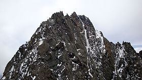
Mont Brouillard (4,069 m) is a mountain in the Mont Blanc massif in the Val d'Aosta, Italy, being a satellite peak on the south ridge of Mont Blanc.
Contents
- Alpinisme mont brouillard 4069 m pointe baretti 4013 m
- Map of Mont Brouillard 11013 Courmayeur Aosta Valley Italy
- Toponym
- Ascent
- References
Map of Mont Brouillard, 11013 Courmayeur, Aosta Valley, Italy
Toponym
Though in French this name means "mountain of mist", this toponym comes from Valdôtain Francoprovençal patois. According to Aostan botanist and scientist Joseph-Marie Henry, the word Broillà means "made of breuils", Breuil meaning alpine marshy berm, as for Breuil in Valtournenche.
Ascent
The question of who made the first ascent of the peak was for a time a matter of contention. Martino Baretti and his guide Jean-Joseph Maquignaz believed that they had climbed the peak, together with Punta Baretti, on 28 July 1880, but Karl Blodig showed that this was unlikely, no cairn being found when he made his ascent on 10 July 1906 with Oscar Eckenstein and Alexis Brocherel. Later research showed that the time that Baretti gave for the traverse between Punta Baretti and Mont Brouillard was "half that required".
The Brouillard ridge to the summit of Mont Blanc does not cross Mont Brouillard, being separated from the peak by the Col Emile Rey.