
Length 34 km | Source Sandre, Géoportail Country France | |
 | ||
Progression | ||
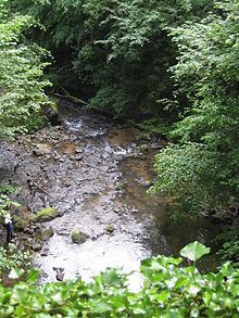
La Monne is a small torrential river that originates in the Puy-de-Dôme, near the col de la Croix-Morand, above the village of Mareuge, at 1,300 metres (4,300 ft) above sea level. It joins the Veyre at 380 metres (1,250 ft). According to the SANDRE database, it is a direct affluent of the Allier and the Veyre is a tributary of the Monne.
Contents
Map of La Monne, France
GeographyEdit
The river is 34.5 kilometres (21.4 mi) long. La Monne is part of a hydrographical whole, draining les monts Dore. The system is made up of rivers flowing eastward into the river Allier in the plains of the Limagne. To the south lies le pays des Couzes with, from south: la Couze d'Ardes, la Couze Pavin and la Couze Chambon; beyond flows la Monne and the Veyre. Continuing north one finds other rivers feeding from la chaîne des Domes : l'Auzon, l'Artière and la Tiretaine which flows through Royat and Clermont-Ferrand.
All rivers descending more than 1,000 metres (3,300 ft) down to about 350 metres (1,150 ft) etch the granitic ridge of la faille des Limagnes +/- deeply from west to east. The most wild and spectacular gorges are those of la Monne located between Olloix and Cournols.