
- location near Charleyong | - elevation 796 m (2,612 ft) - elevation 556 m (1,824 ft) | |
 | ||
- left Northangera Creek, Warrambucca Creek, Tantulean Creek, Cookanulla Creek - right Feagans Creek, Nettletons Creek | ||
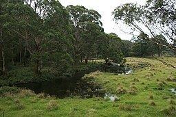
The Mongarlowe River is a perennial river of the Shoalhaven catchment located in the Southern Tablelands region of New South Wales, Australia.
Contents
Map of Mongarlowe River, New South Wales, Australia
Location and features
The river rises on the western slopes of the Great Dividing Range within the Monga National Park about 6.5 kilometres (4.0 mi) east southeast of the village of Araluen. The river flows generally north, joined by six minor tributaries before reaching its confluence with the Shoalhaven River approximately 3 kilometres (1.9 mi) northwest of the locality of Charleyong. The river descends 242 metres (794 ft) over its 72 kilometres (45 mi) course.
The river is crossed by the Kings Highway northwest of Clyde Mountain.
References
Mongarlowe River Wikipedia(Text) CC BY-SA