
Elevation 781 m | ||
 | ||
Similar Brown Mountain, Pigeon House Mountain, Big Badja Hill, Mount Royal, Grattai Mountain | ||
Clyde mountain run
Clyde Mountain, at an elevation of 781 metres (2,562 ft) , is a mountain in the Southern Tablelands region of New South Wales, Australia.
Contents
- Clyde mountain run
- Map of Clyde Mountain Monga NSW 2622 Australia
- Fast descent down clyde mountain on mountain bikes
- Location and features
- References
Map of Clyde Mountain, Monga NSW 2622, Australia
Fast descent down clyde mountain on mountain bikes
Location and features
Clyde Mountain is located in the Great Dividing Range within the Monga National Park. The mountain is approximately 18 kilometres (11 mi) east of the town of Braidwood, approximately 20 kilometres (12 mi) from the village of Nelligen, and approximately 27 kilometres (17 mi) west of the main coastal centre of Batemans Bay on the NSW South Coast.
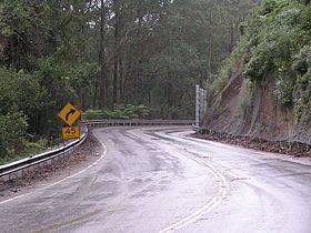
The road leading up towards the summit of Clyde Mountain is a 5 kilometres (3.1 mi) section of steep, winding section of the Kings Highway in New South Wales, Australia. It is the location of many crashes, 22% of all incidents on the Kings Highway occurring on a 40 kilometres (25 mi) stretch on and near the mountain. There are three safety ramps (runaway truck ramps) for trucks or heavy vehicles which lose control of their speed or suffer brake failure. Slow vehicle turnouts have been added on the Clyde Mountain descent, which allows vehicles to pass trucks in low gear.