Area 330.3 km² Local time Wednesday 9:31 PM | Phone number 0233-43-2111 Population 9,314 (Oct 2013) | |
 | ||
Weather 0°C, Wind NW at 3 km/h, 82% Humidity Points of interest Semi Hot Spring, Ohori Hot Spring, Mt. Kamurodake, Omatayama, Kamewariyama, Mt. Gongen | ||
Mogami (最上町, Mogami-machi) is a town in Mogami District, Yamagata, Japan.
Contents
- Map of Mogami Mogami District Yamagata Prefecture Japan
- Geography
- Neighboring municipalities
- History
- Economy
- Railways
- Highways
- References
Map of Mogami, Mogami District, Yamagata Prefecture, Japan
As of October 2013, the town has an estimated population of 9,314 and a population density of 28.2 persons per km2. The total area is 330.27 square kilometres (128 sq mi).
Geography
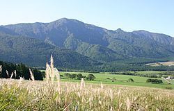
Mogami is located in the mountains of extreme north eastern Yamagata Prefecture. Despite its name, the Mogami River does not run through the town. The area is known for extremely heavy snows in winter.
Neighboring municipalities
History
During the Sengoku period, the area was under the control of the Mogami clan who built Oguni Castle. During the Edo period, parts of the area came under the control of Shinjō Domain. After the start of the Meiji period, the area became part of Mogami District, Yamagata Prefecture. The villages of Higashi-Oguni and Nishi-Oguni were established on April 1, 1889. These villages were merged to form the town of Mogami on September 1, 1954.
Economy
Mogami was formerly known as a horse breeding area, and numerous ranches supplied horses to the Imperial Japanese Army's cavalry regiments. Modern Mogami is dependent on agriculture, forestry and seasonal tourism to its many hot spring resorts.
