
Phone number 0229-63-3111 Population 24,418 (May 2014) | Area 460.8 km² Local time Saturday 7:53 PM | |
 | ||
Weather 4°C, Wind W at 6 km/h, 73% Humidity | ||
Kami (加美町, Kami-machi) is a town located in Miyagi Prefecture, Japan. As of May 2014, the town had an estimated population of 24,419 and a population density of 53 persons per km2. The total area was 460.82 km2.
Contents
- Map of Kami District Miyagi Prefecture Japan
- Geography
- Neighboring municipalities
- History
- Economy
- Railway
- National highways
- Noted people from Kami
- References
Map of Kami District, Miyagi Prefecture, Japan
Geography
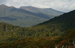
Kami is located in west-central Miyagi Prefecture, bordered by Yamagata Prefecture to the west.
Neighboring municipalities
History
The area of present-day Kami was part of ancient Mutsu Province, and has been settled since at least the Jomon period by the Emishi people. During later portion of the Heian period, the area was ruled by the Northern Fujiwara. During the Sengoku period, the area was contested by various samurai clans before the area came under the control of the Date clan of Sendai Domain during the Edo period, under the Tokugawa shogunate.
The modern town of Kami was created on April 1, 2003, as a result of a merger between three towns, Miyazaki, Nakaniida, and Onoda, all from Kami District.
Economy
The economy of Kami is largely based on agriculture, primarily the cultivation of rice.
Railway
Kami is not currently served by any railway lines.