
OS grid SH658345 Elevation 623 m | Topo map OS Landranger 124 Prominence 180 m | |
 | ||
Listing Marilyn, Hewitt, Nuttall Similar Foel Penolau, Rhinog Fawr, Rhinog Fach, Diffwys, Y Llethr | ||
Moel ysgyfarnogod dance
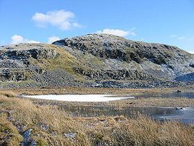
Moel Ysgyfarnogod (Bare hill of the hares in Welsh) is a mountain in Snowdonia, North Wales and is the northernmost of the Rhinogydd. Rhinog Fawr lies directly south.
Contents
Map of Moel Ysgyfarnogod, Talsarnau, UK
It overlooks Llyn Trawsfynydd, and from the summit it is possible to see the towns of Porthmadog and Blaenau Ffestiniog. It may be climbed from Trawsfynydd in the east, or from Talsarnau in the west.
To the north-west of the summit, on an area of moorland and rocky outcrops, lies Bryn Cader Faner, an ancient stone circle. It is one of the finest examples of a Bronze Age cairn in Britain, and has rocky standing stones along its circumference.
References
Moel Ysgyfarnogod Wikipedia(Text) CC BY-SA