
Population (2015) 2,307 Founded October 1977 | ||
 | ||
Weather 12°C, Wind NW at 5 km/h, 71% Humidity | ||
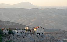
Mitzpe Yeriho (also spelled “Mitzpeh Yericho”) (Hebrew: מִצְפֵּה יְרִיחוֹ, lit. Jericho Lookout) is a religious communal Israeli settlement in the West Bank. Located 20 km east of Jerusalem and 10 km east of Ma'ale Adummim along Highway 1 in the Judean desert, it falls under the jurisdiction of Mateh Binyamin Regional Council. In 2015 it had a population of 2,307.
Contents
Map of Mitspe Yeriho
Geography
The village lies on one of the last cliffs marking the edge of the Judean highlands, and overlooks the Jordan Rift Valley, the Dead Sea, and the ancient city of Jericho whence its name is derived. The climate is dry, with temperatures a few degrees warmer than Jerusalem temperatures all year round.
History
Founded in October 1977 during the Jewish holiday of Sukkot, it was supposed to be located on government lands adjacent to Jericho. Due to the objection of then Defense Minister Ezer Weizman, they were moved to Mishor Adumim. Agriculture Minister Ariel Sharon suggested a few days later that they relocate to a barren hilltop overlooking Jericho, its current location.
The original residents were a mixed group of both religiously observant and non-observant Jews. They later split up into two groups, and the non-observant members established a new settlement, Vered Yericho, located in the Jordan Valley below Mitzpe Yeriho and closer to Jericho. Still, Mitzpe Yeriho is a community of various traditions and observance levels. While the main synagogue follows Ashkenazi traditions, there are also two Sephardi synagogues, a Chabad synagogue, a Yemenite synagogue, a Carlebach minyan and several other small functioning minyanim.
In 1982, the community appointed then 27-year-old Yehuda Kroizer as community rabbi. Rabbi Kroizer gives regular classes, both in the town as well as in the Yeshivat HaRaayon HaYehudi, the former yeshiva of Rabbi Meir Kahane.
The yeshiva Netivot Yoseph, a leading Religious Zionist yeshiva headed by Rabbi Shabtai Sabbato, was founded in 1990, and moved the following year to Mitzpe Yeriho. The yeshiva is well known for its emphasis on breadth of Talmudic studies (bekiyut). It frequently honors students who have completed studying the entire Talmud; in 2011, there was a special celebration of 100 graduates who completed Shas.
In May 1997, the Israeli Defense Forces dismantled two illegally placed mobile homes in Mitzpe Yeriho.
Demographics
In 2009, the population of Mitzpe Yeriho grew at an annual rate of 5.6%. As of 2010, over 450 families reside in Mitzpe Yeriho.
Environment
In 1999, Mitzpe Yeriho was found to be a "radon-prone" area. Such an area is defined as one in which the radon concentration is more than 10 times the national average in more than one percent of the homes in the area.
Economy
The community is home to several businesses including an electronics facility, and also serves tourism in the nearby Wadi Qelt nature reserve and its Byzantine-era Saint George Monastery and Hasmonean-era Kypros fortress. It also hosts the Nof Harden wedding hall.