
Area 15,907 km² | ||
 | ||
Minqin County (Chinese: 民勤县; pinyin: Mínqín Xiàn) is an administrative district in Gansu, the People's Republic of China. It is one of 58 counties of Gansu. It is part of the Wuwei prefecture, with the city of the same name being the prefecture seat. Its postal code is 733300, and its population in 1999 was 281,826 people.
Contents
Map of Minqin, Wuwei, Gansu, China
In older literature, today's Minqin is referred to as Zhenfan (镇番, Wade-Giles: Chen-fan). According to Pyotr Kozlov, the Mongol name for the city was Sogo Khoto.
Geographically, Minqin county occupies one of Gansu's panhandles, bordering in the north, east, and southeast on the Alashan League of Inner Mongolia.
History
Historically, Chinese agricultural settlement in the area was made possible by the Shiyang River, flowing from the Qilian Mountains. However, the livelihood of Chinese farmers here was often precarious; in the 1920s it was considered as somewhat of a regular famine district. Large number of Zhenfan people, nicknamed "Sand-hollow Mice", worked as "camel-pullers" with caravans owned by Mongols from the adjacent Alashan, or moved—temporarily or permanently—to Xinjiang. For example, as of 1926, the main population of the small oasis of Santanghu (now, officially, Santanghu (三塘湖) township) in what's today Barkol Kazakh Autonomous County of Xinjiang were migrants from Minqin (Zhenfan) and their descendants.
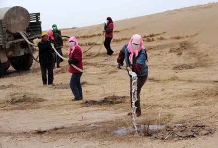
By the late 20th century, the environmental situation in the Minqin area deteriorated, as smaller amounts of the Shiyang River water reached the area, due to the increased irrigation of use of it upstream. Ground water levels fell, and desertification became a serious threat. Minqin is now identified as one of the major sources of sandstorms in China.