
Province Gansu | Country China | |
 | ||
Similar Qinghai Lake, Jiayu Pass, Kumbum Monastery, Yumen Pass, Mogao Caves | ||
The Qilian Mountains also known as Richthofen Range, (Tsilien Mountains; Chinese: 祁连山; pinyin: Qílián Shān; Wade–Giles: Ch'i2-lien2 Shan1; Mongghul: Chileb), together with the Altyn-Tagh (Altun Shan) also known as Nan Shan (Chinese: 南山, literally "Southern Mountains", as it is to the south of Hexi Corridor, is a northern outlier of the Kunlun Mountains, forming the border between Qinghai and the Gansu provinces of northern China.
Contents
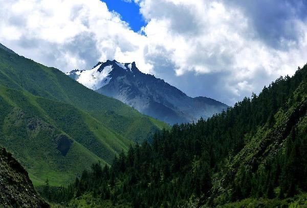
Map of Qilian Mountain, Sunan, Zhangye, China
Geography
The range stretches from the south of Dunhuang some 800 km to the southeast, forming the northeastern escarpment of the Qinghai-Tibet Plateau and the southwestern border of the Hexi Corridor.
The eponymous Qilian Shan peak, situated some 60 km south of Jiuquan, at 39°12′N 98°32′E, rises to 5,547 m. It is the highest peak of the main range, but there are two higher peaks further south, Kangze'gyai at 38°30′N 97°43′E with 5,808 m and Qaidam Shan peak at 38°2′N 95°19′E with 5,759 m. Other major peaks include Gangshiqia Peak in the east.
The Nan Shan range continues to the west as Yema Shan (5,250 m) and Altun Shan (Altyn Tagh) (5,798 m). To the east, it passes north of Qinghai Lake, terminating as Daban Shan and Xinglong Shan near Lanzhou, with Maoma Shan peak (4,070 m) an eastern outlier. Sections of the Ming Dynasty's Great Wall pass along its northern slopes, and south of northern outlier Longshou Shan (3,616 m).
The Qilian mountains are the source of numerous, mostly small, rivers and creeks that flow northeast, enabling irrigated agriculture in the Hexi Corridor (Gansu Corridor) communities, and eventually disappearing in the Alashan Desert. The best known of these streams is the Ejin (Heihe) River.
The characteristic ecosystem of the Qilian Mountains has been described by the World Wildlife Fund as the Qilian Mountains conifer forests.
Biandukou (扁都口), with an altitude of over 3500 m, is a pass in the Qilian Mountains. It links Minle County of Gansu in the north and Qilian County of Qinghai in the south.
History
The Shiji mentions the "Qilian mountains" together with Dunhuang in relation to the homeland of the Yuezhi. This Qilian however has been suggested to be the mountains now known as Tian Shan, 1,500 km to the west. Dunhuang has also been argued to b the Dunhong mountain. Qilian (祁连) is said to be as a Hunnic word meaning "sky" (Chinese: 天) according to Yan Shigu, a Tang Dynasty commentator on the Hanshu.
The mountain range was formerly known in European languages as Richthofen Range after Ferdinand von Richthofen, who was the Red Baron's explorer-geologist uncle.
The mountain range gives its name to Qinghai's Qilian County.