
Topo map USGS Miller Peak Elevation 2,885 m | Easiest route Trail Hike Prominence 1,526 m Parent range Huachuca Mountains | |
 | ||
Listing US most prominent peaks 126th Similar Carr Peak, Chiricahua Peak, Mount Glenn, Apache Peak, Thimble Peak | ||
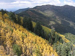
Miller Peak, at 9,470 feet (2,886 m), is the second-highest mountain in Cochise County, Arizona (after Chiricahua Peak). Located approximately 10 miles south of Sierra Vista, Arizona, it is the highest mountain in the Huachuca mountain range and a popular local hiking destination. The peak is the highest point in the Miller Peak Wilderness on the Coronado National Forest. The area was affected by the 2011 Monument fire and most of the pine trees seen in older photographs were burned and destroyed. Scrub oak are beginning to replace the areas that were previously covered by pine.
Contents
Map of Miller Peak, Sierra Vista Southeast, AZ 85615, USA
Hiking up Miller PeakEdit
The summit of Miller Peak can be gained by any of several trails, which all involve moderately strenuous hikes requiring approximately 3,500 feet (1,100 m) in elevation gain and 9 to 11 miles (14 to 18 km) distance round-trip. Perhaps the most well-known trailhead is found at the end of Miller Canyon Road, near Hereford, Arizona. Other popular trails include the Montezuma Pass trailhead in the Coronado National Forest and the Carr Peak trailhead, but the short trail to the summit off the main Crest Trail can be reached from nearly any other trail in the Huachucas. Notable landmarks along the way include Bathtub Springs and Bear Saddle. Nearby Carr Peak (9,229 ft or 2,813 m) can be reached in the same day, along the Crest Trail.
Those attempting to hike to the summit of Miller Peak should bring at bare minimum 3 liters of water, especially in the summer months. The humidity in winter is very low (< 15%) so bring more water than you expect even when the temperatures are not high. In winter snow storms are common. In summer fierce lightning storms and flash floods hit the peaks so do not hike in summer when thunderstorms are present. Hikers should also be aware the area is frequented by illegal immigrants and drug runners crossing over from Mexico, just a few miles away. Always be aware of your surroundings. Although traffic has decreased in recent years, trash from recent illegal travelers is easily evident. You will also occasionally cross paths with Border Patrol agents as they also hike the area on patrol.