
Official name Middle Letaba Dam Opening date 1984 Opened 1984 Surface area 18.79 km² | Type of dam earth-fill Height 38 m Length 2,600 m Total capacity 173.1 million m³ | |
 | ||
Operator(s) Department of Water Affairs and Forestry Similar Tzaneen Dam, Albasini Dam, Luphephe Dam, Nandoni Dam, Dap Naudé Dam | ||
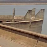
Middle Letaba Dam is an earth-fill type dam located on the Middle Letaba River, 40 Km east of Elim and 40 Km west of Giyani, Limpopo, South Africa. The source of the Middle Letaba river rises high in the tropical mountains of Magoebaskloof near Tzaneen, where rainfall is abundant during the summer months. The river passes numerous villages and its flow becomes quite strong when it reaches the village of Magoro.
Map of Middle Letaba Dam, South Africa
When in full capacity, the Middle Letaba becomes Limpopo's third largest dam, but the Middle Letaba Dam only reaches its full capacity when the river is in flood. The dam seldom reaches its full capacity because the ZZ2 agricultural farms in Mooketsi also rely on the water from the Middle Letaba river, resulting in less water reaching the Middle Letaba Dam.
Construction of the dam started in 1980 under Gazankulu government and serves mainly for water supply to Giyani and Hlanganani. The dam is situated alongside the R578 road (South Africa) to Giyani and Elim. The hazard potential of the dam has been ranked high (3). The dam is popularly known as 'Sterk Rivier Dam' by the local people, the name Sterkrivier (Strong river) was given by the Afrikaner people, it is said that before the construction of the dam in 1980, the water that used to flow in this river was so powerful to an extent that a new name was given to the river, hence 'Sterkrivier'.