
- elevation 4,254 ft (1,297 m) - average 257 cu ft/s (7.28 m/s) Basin area 2,088 km² Basin area 2,088 km² | - elevation 2,192 ft (668 m) Length 118 km Discharge 7.277 m³/s | |
 | ||
- max 4,730 cu ft/s (133.94 m/s) | ||
Middle fork john day river wild salmon habitat restoration
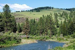
The Middle Fork John Day River is a 73-mile (117 km) tributary of the North Fork John Day River in the U.S. state of Oregon. It originates in the Blue Mountains of northeast Oregon in the Malheur National Forest near Austin and flows generally west to the North Fork about 18 miles (29 km) above Monument. The Middle Fork drainage basin covers about 806 square miles (2,090 km2).
Contents
- Middle fork john day river wild salmon habitat restoration
- Map of Middle Fork John Day River Oregon USA
- Bates oregon salmon spawning middle fork john day river videotaped by norm rasmussen
- References
Map of Middle Fork John Day River, Oregon, USA
The Oregon Scenic Waterways Program, administered by the Oregon Parks and Recreation Department (OPRD) protects the river for most of its length. The state lists a 60-mile (97 km) segment of the Middle Fork from about 71 miles (114 km) from the mouth to about 11 miles (18 km) from the mouth as a Scenic River Area and the lower 11 miles (18 km) as a Natural River Area. People planning to cut trees, mine, build roads or structures, or to make other substantial changes within 0.25 miles (0.40 km) of the river must first notify OPRD and seek its approval.