
- elevation 4,872 ft (1,485 m) Basin area 2,751 km² | - elevation 928 ft (283 m) | |
 | ||
The Middle Fork Feather River is a major river in Plumas and Butte Counties in the U.S. state of California. Nearly 100 miles (160 km) long, it drains about 1,062 square miles (2,750 km2) of the rugged northern Sierra Nevada range.
Contents
Map of Middle Fork Feather River, California, USA
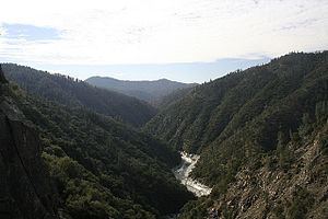
It rises near Beckwourth, formed by the confluence of several streams in a large mountain-surrounded basin, the Sierra Valley called the Sierra Valley Channels. The largest is Little Last Chance Creek, which flows from the northeast side of the valley. The river flows west, passing Portola and turning northwest at Clio. It then enters the Plumas National Forest, turning westwards into a gorge. Nelson Creek enters from the left, then Onion Valley Creek a few miles onward. Bear Creek, Willow Creek and the North Fork Middle Fork Feather River all come in from the right as the river courses west-southwest through a tight, steep canyon strewn with rapids. It is then joined by the South Branch Middle Fork Feather River from the left. As the river widens into an arm of Lake Oroville, a reservoir formed by the Oroville Dam, the Fall River joins from the left. The reservoir is fed by the North, Middle, West and South Forks of the Feather River, which once joined in the valley to form the main Feather River. That river continues southwards to join the Sacramento River near the unincorporated community of Plumas Landing.
One of the Middle Fork Feather's tributaries, the Fall River, feeds the 640-foot (200 m) Feather Falls. This waterfall is often claimed to be the third or sixth tallest in the United States; but in reality is nowhere near the top ten in height.
Wild and Scenic River
The Middle Fork is recognized by the US Government for its untamed beauty and is designated a National Wild and Scenic River for 77.6 miles of its length. The 32.9 mile stretch inaccessible to roads is home to some of the best wild trout fishing in California.
Grizzly Valley
The Grizzly Valley is a 21 sq mi (54 km2) landform of the upper Middle Fork Feather watershed that receives 29-37 inches of annual precipitation. The valley is the location of Lake Davis, an impoundment of Big Grizzly Creek by the 1967 Grizzly Valley Dam.