
 | ||
Miangas or Palmas is North Sulawesi's northernmost island, and one of 92 officially listed outlying islands of Indonesia.
Contents
- Map of Miangas Kepulauan Talaud Regency North Sulawesi Indonesia
- Presiden jokowi resmikan bandara miangas
- Etymology
- History
- First Europeans
- The Island of Palmas Case
- Post Indonesian independence
- Geography
- Transportation
- Economy
- Demography
- References
Map of Miangas, Kepulauan Talaud Regency, North Sulawesi, Indonesia
Presiden jokowi resmikan bandara miangas
Etymology
Miangas means "exposed to piracy", because pirates from Mindanao used to visit the island. In the 16th century, the island was named in Spanish Isla de las Palmas, and in Portuguese Ilha de Palmeiras. In the Sasahara language, the island is called Tinonda or Poilaten, which mean "people who live separated from the main archipelago" and "our island" respectively.
History
According to local tradition, there were a number of kingdoms in the area. Sangir, Talaud and Sitaro belonged to two kingdoms, Tabukan and Kalongan. To justify their sovereignty over Miangas, the Dutch argued that the island had been under the domination of the princes of Sangir.
First Europeans
In October 1526, Garcia Jofre de Loaísa, Spanish sailor and researcher, was the first European to visit the island.
The island was used as a defense site by Talaud people when under attack from the Sulu Sultanate.
The island was affected by the outbreak of cholera in 1885, causing hundreds of the inhabitants to move to Karakelang Island.
In 1895, E. J. Jellesma, Oud-resident of Manado, visited Miangas to praise the residents and kapiten laut for rejecting the Spanish flag. Jellesma gave them a medal and a Dutch flag. With Jellesma was Pastor Kroll, who baptized 254 residents as Protestants. After Jellesma's visit, a Tahuna assistant resident and Pastor Pannings visited the island in April and October 1909.
The Island of Palmas Case
According to the Treaty of Paris, the Philippines area was all areas within a large geographic box. Miangas lay inside the southern boundary of the box. On 21 January 1906, General Leonard Wood, Governor General of Moro, officially visited the island for the first time. He found the Dutch flag already flew there and that the island was claimed as part of the Dutch East Indies. When Wood returned to Zamboanga, he reported it to the United States Military Secretary, on 26 January 1906. The United States government referred the matter to the Netherlands through their embassy in The Hague on 31 March 1906. On 17 October 1906 the Netherlands Foreign Ministry responded with reasons why the island was included in the Dutch East Indies. On 23 January 1925 the Netherlands and the United States brought the case to the Permanent Court of Arbitration, under a sole arbitrator Max Huber of Switzerland. On 4 April 1928 Huber decided that the island "forms in its entirety a part of Netherlands territory".
Post Indonesian independence
On 4 July 1956, Indonesia, represented by Ambassador Soehardjo Wirjopranoto, and the Philippines, represented by Ambassador Jose T. Fuentebella, signed the Agreement on Immigration Between the Republic of the Philippines and the Republic of Indonesia, that allowed border residents in Sangihe, Talaud, Nunukan, Balut, and Sarangani, who had a laissez-passer, to cross the border to trade, visit family, worship, and travel. On 16 September 1965, Jusuf Ronodipuro of Indonesia and Leon T. Garcia of the Philippines signed a Directives and Guidelines on the Implementation of the Immigration Agreement on Repatriation and Border Crossing Arrangement Between Republic of Indonesia and the Republic of the Philippines, which clarify the first agreement, making Marore, Miangas, Mabila, and Balut the checkpoints.
In 1972, the island was hit by a tsunami, and 90 householders were moved by the government to Bolaang-Mongondow Regency as a result.
In 2005, the Indonesian government refused a shipping line from Miangas to Davao (part of the Philippines). In the same year, Miangas Village Secretary Jhonlyi Awala died from a beating at the hands of the Chief of Police of Miangas. About 200 people, dressed in black, demonstrated to express their outrage at the senseless death and the island's neglect by the Indonesian state. They lowered the Indonesian flag at the Miangas pier and greeted with the Philippine flag Talaud Regent Elly Engelbert Lasut, who arrived from Manado to de-escalate the situation.
In February 2009, Philippine Tourism Authority published a map which included Miangas as the Philippines' territory. According to Indonesian Foreign Ministry's spokesman, the map was probably made by private company, not by the Philippine government.
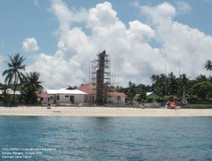
A monument, named Monumen Patung Santiago (Monument Statue of Santiago), was built on the island in 2010 to commemorate Santiago who defended the island from the Dutch colonials. In 2011, the island could be reached by ship operated by Pelni.
Geography
Miangas is located 521 km (324 mi) from Manado, the capital of North Sulawesi and 126 km (78 mi) from Davao City in the Philippines. It also lies 80 km (50 mi) southeast of Mindanao. It is 3 km (2 mi) long and 1.2 km (3⁄4 mi) wide, with an area of 3.15 km2. Miangas belongs to Nanusa district, Talaud Islands Regency. The island is mainly lowland, about 1.5 metres above sea level. The highest point, called Gunung Batu, is 111 metres high, located in the northeast part of the island. This area is covered with coconut palm. In the northeast corner of the island, there is a 46 metre high cliff, with the northeast shore fringed by a 320 m (0.2 mi) reef.
Transportation
For transportation, Miangas inhabitants once relied on their homemade sailboats. During the New Order, however, they started using motorboats. These are now the main sources of transportation.
Economy
Miangas inhabitants derive their main income from fishing. Women also weave mats from pandan leaves.
Demography
As at the 2010 Census, the island's population was 728 people. Miangas inhabitants speak Indonesian and Bisaya; the older generation usually also speak Tagalog.
The island has a police station and two military posts. There are also a market, a harbor office and a bank office.