
Last eruption Unknown Prominence 435 m | Elevation 435 m | |
 | ||
Similar Nabukelevu, Zealandia Bank, Metis Shoal, Fonualei, Farallon de Pajaros | ||
Mehetia boat trip spearfishing
Meheti'a or Me'eti'a is a volcanic island in the Windward Islands, in the east of the Society Islands in French Polynesia. This island is a very young active stratovolcano 110 kilometres (68 mi) east of the Taiarapu Peninsula of Tahiti. It belongs to the Teahiti'a-Mehetia hotspot.
Contents
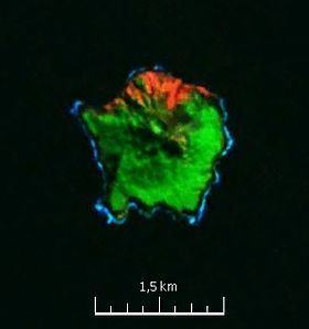
Map of Meheti'a, French Polynesia
The island has an area of 2.3 square kilometres (0.89 sq mi) and its highest point is 435 metres (1,427 ft). Meheti'a's well-defined volcanic crater contains a very active hot point. In 1981 the island was the centre of earthquakes.
History
The first European sighting was by the Spanish expedition of Pedro Fernández de Quirós on 9 February 1606, that charted it as Decena (ten in Spanish). Later on it was sighted by Samuel Wallis in HMS Dolphin 1767. It was also sighted by Spanish navigator Domingo de Boenechea on November 6, 1772 on ship Aguila. He named this island San Cristóbal.
Administration
Meheti'a is administratively part of the commune (municipality) of Taiarapu-Est and of its easternmost commune associée Tautira. The island is uninhabited and doesn't have much vegetation but has a small coral reef on the underwater slopes.